Hi Persistentone
I'd prefer to answer your question under "Canning Basin Overview" subject rather than answering on "Buru vs NSE" thread, however this thread has already gone a long way. Therefore I'll write here.
Thanks for the question. I was thinking to make this kind of post again because the post I made on Friday was lost in the crowd. It was Post #: 9048390, was questioning the prospectivity of Goldwyer formation and its sweet spots.
I always said; NSE is fishing for the big fishes on the Ocean, but not interested in the small fishes of estuaries. That why I like it.
That's why NSE is spending a lot of money for fishing on the extreme remote part of Kidson sub-basin and Crossland Platform which is also a part of Kidson sub-basin.
Other explorers still couldn't find the sweet spot of wet-gas window in Canning which would host the billions of barrels of oil and tens of TCFs of gas. The oil fields which have found in Canning so far, can not be considered (and proved) as huge oil fields (not even 100m barrels of oil). There is no Thermal Maturity Model confirmed in any area and no wet-gas window conditions are confirmed other than Nicolay-1 well's location.
NSE's play is only related with Goldwyer formation in Goldwyer project. This is pre-salt play. (It's not post salt play as Chris said). Laurel and Anderson formations are dominated the Fitzroy Trough and Gregory Trough basins. They are post salt plays. I think Gregory basin is more prospective than Fitzroy Trough as the Eastern part of Canning Basin should have more prospectivity. This is the most important part of my theory here. Same thing is correct for Kidson Sub-basin. (Nicolay-1 well was at the west but not east).
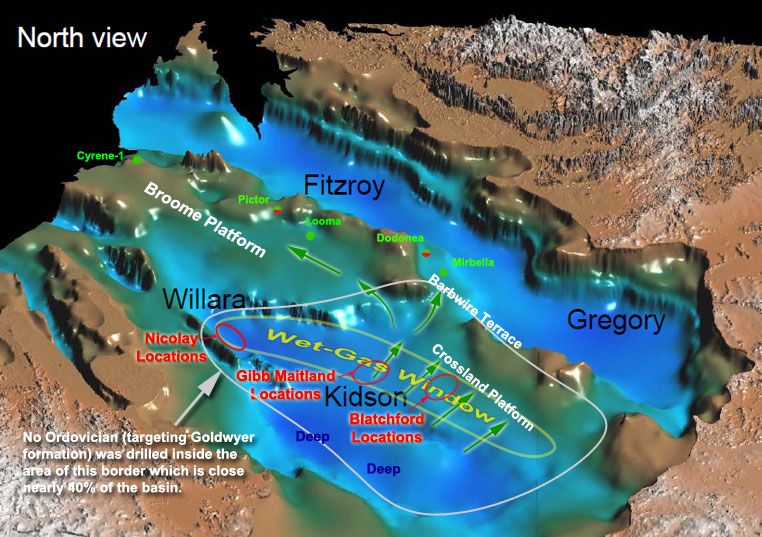
This is because Canning basin remained as a close in restricted conditions in Ordovician when the sea levels were high. Closed embayment and restricted conditions are more likely to favour source rock development than an open seaway. Furthermore, in the case of enclosed embayment, source rock conditions might be expected to improve inboard away from the open ocean. (See below)
Buru is dominated the Fitzroy Trough. They have some exposure to Gregory Basin through NSE's tenements as well. NSE has big tenements in Gregory Basin by 50% and 60% in two tenements which is shared with Buru and Green Rock Energy.
I have read Buru's "Independent Resource Assessment Laurel Wet Gas Accumulation, Canning Superbasin". I agree that Buru has got tens of TCFs of gas. It is "WORLD CLASS" IMO now. But I don't agree Buru has got 1.1 billion barrel of oil! They are not telling where this billion barrel is coming from! Conventional or unconventional! They are not showing the source of this oil in the report! I can't see any wet-gas window or anything like that on Buru's tenements. IMO, they have many Ungani like conventional plays (towards to old REY tenements). The total oil resource may reach to 100m-200m barrels. IMO, Buru is exaggerating their oil potential as oil is more valuable than gas in the market opinions.
Let's leave Buru aside and talk about NSE. Let's start from the beginning;
We all knew that NSE was drilling on a remote area
It was very well known from the start that NSE would be drilling on a very remote part of the basin which would bring some cost increases. That was the reason that no wells were drilled on this huge area; North of Kidson Sub Basin and Crossland Platform. It has been always very remote as it is now. Therefore drilling would be expensive here.
The geology of Canning Basin is still lightly understood. as very little number of wells drilled so far. Therefore a huge number of wells need to be drilled to understand the geology.
More interestingly, there are no wells drilled on the huge area of centre and north Kidson sub-basin and Crossland platform which is the candidate to be the sweet spot of Canning Basin in my opinion (supported by many geologists' opinions)
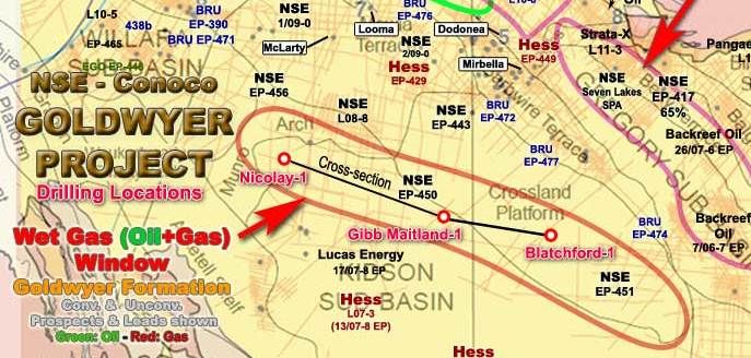
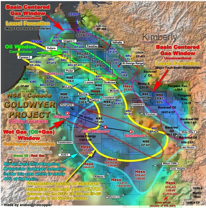
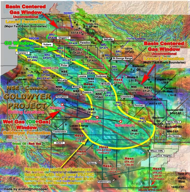
Let's look at this map first. See the Crossland Platform. No wells are drilled. (Black dots are the wells) And see the south of Crossland Platform which is the northern Kidson sub-basin. Let's not forget, Crossland Platform is part of Kidson sub-basin. (There is only one well on top of the Crossland Platform; Crossland-2. But it was only drilled to about 950m 40 years ago)
And now see the huge area of Canning Basin on this map with other details.
MAP 1
Q - Why is NSE so keen to prove up the Ordovician Goldwyer Source Rocks in Canning Basin
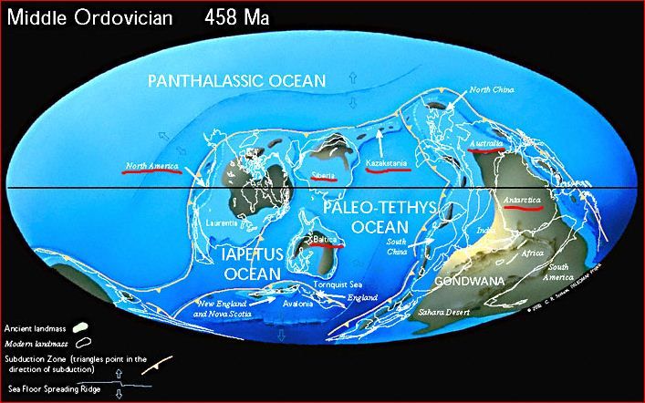
Answer 1 - Because Australia was one of the lucky land masses just located on the Equator during the Ordovician time.
Others were only; North America, Siberia, Kazakhstan, Baltic and Antarctica. We all know that there are huge reserves and petroleum production on all of these regions now (other than Antarctica). G.Prisca algal organic matter bearing source rocks are responsible for all these resources. It generated petroleum in all those basins. That is called "Ordovician petroleum System". That's why what we are chasing the same source rocks in Canning atm.
"The great volume of Upper Ordovician carbonate reservoir rocks and transgressive shale source rocks were the result of wide-spread marine transgression across the North American continent during the Palaeozoic. The correlation of these units across several basins is shown in Figure 6. Foster et al (1986) correlated the Ordovician Goldwyer Formation source rocks of the Canning Basin with source rocks in the Baltic, Michigan, Illinois, Williston, and Amadeus Basins on the basis of presence of Gloeocapsamorpha prisca. G. prisca-bearing source rocks are claimed to be responsible for commercial accumulations of hydrocarbons in the Amadeus, Baltic, Michigan–Illinois, and Williston Basins, each of which, including the Canning Basin, lay within 5 of the equator during the Ordovician" Source: Canning Basin & Global Palaeozoic Petroleum Systems Review 2005
Answer 2 - Oil associated with Ordovician Petroleum System, petroleum system, so the Goldwyer source rocks has been recovered in wells drilled on North and North-Western part of Kidson sub-basin.
These are Barbwire Terrace (Dodonea 1, Mirbella-1, Percival 1 and Solanum 1), the Dampier Terrace (Edgar Range 1 and Pictor 1), Broome Arch (Looma 1) and along the Admiral Bay fault zone (Cudalgarra 1, Great Sandy 1 and Leo 1). And now in Cyrene-1 on Broom Platform!
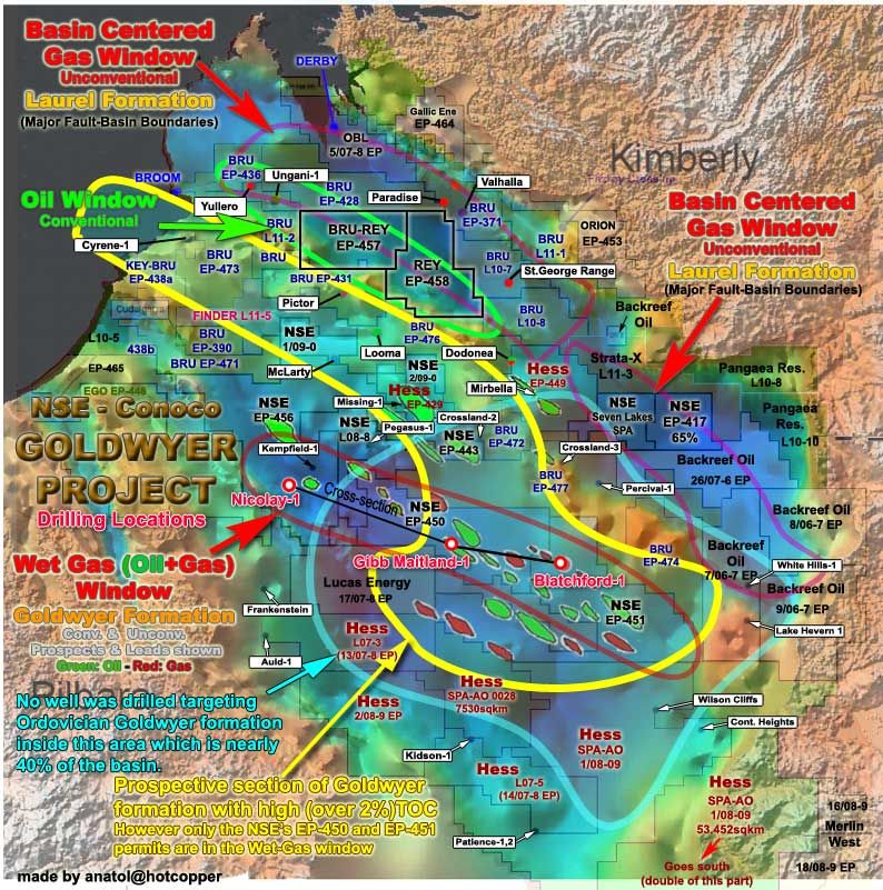
You can see all these wells which the oil was recovered, on the Map 4 above.
Q - Is the Goldwyer formation in Broom Platform, Barbwire Terrace, Dampier Terrace, etc. mature enough to generate oil? Or is it coming from another location?
Answer - No! None of these locations are mature enough to generate oil IMO. The Goldwyer sourced oil is coming from the Kidson sub-basin and its Crossland Platform.
NSE and Conoco also think the same thing. In the nature, it's very hard to find the right conditions for generating the oil. (much harder than generating the gas). Those locations don't comply with these conditions.
IMO, the Goldwyer sourced oil have had a tortuous migration pathway to get to those terraces and platforms from the pre-salt Goldwyer Formation in deeper reaches of the Kidson Sub-basin, where it is most likely generated.
Here is what I mean in graphic mode;
Thermal Maturity Model and Wet-Gas window are confirmed in Nicolay-1 location in Kidson sub-basin, but what's next?
The problem is to find everything together. These 3 things are the most important; Thermal Maturity Model Wet-Gas window confirmed high TOC levels.
Actually Kidson sub-basin and its Crossland Platform have been considered for being a candidate as the most prospective area in Canning by most geologists. But no one put a serious drilling rig on this area, as it would be very expensive, maybe not commercial just a few years ago as fracturing the shales is a new technology.
Now looking for higher TOC levels in the same wet-gas window in Gibb Maitland and Blatchford locations
It is the northern slopes of Kidson sub-basin where the Gibb Maitland-1 is now being drilled and the southern slopes of the Crossland Platform where the Blatchford-1 is going to be drilled. I was making more research about the Canning basin in recent days as I had more time. Because the Thermal Maturity Model and Wet-Gas window are confirmed at this level of the basin by Nicolay-1 well, than I was questioning the TOC levels of the basin, looking every well data once more.
Nicaloy-1 location has 1% TOC level. This is not a commercially valuable value (for today). We need to find something over 2% in the wet-gas window.
You may remember the TOC levels of McLarty-1 well which was giving on a NSE presentation before. It is on the Broom Platform. There were around 2.4% to 3.6% TOC levels for Lower Goldwyer units. It is possible to produce huge amount of oil and gas from that kind of shale, however it's neither in the wet-gas nor the oil window. (No suitable conditions for generating the oil)
The Ellis Location was going to be drilled there first but it was changed to Nicolay-1 location after Conoco was involved in the desktop studies. I think it was because they thought that the Ellis Location wouldn't confirm the Thermal Maturity Model and Wet-Gas window at that location.
CROSLAND PLATFORM COULD BE THE SWEET SPOT OF CANNING
The key point here is, and that's why the JV is drilling on this very remote area is, Crossland Platform is the only area which could be the strongest candidate for huge oil and gas potential in Canning. They think that the oil and gas is generated in the Goldwyer sources rocks of northern Kidson Sub-basin and Crossland Platform by the rich organic matter (high TOC) and reached to right thermal maturity and stayed in the Wet-gas window.
Especially Crossland Platform has been the transgression (see goes over the land) beach and shore area and it was open to the western marine tides and currents in the Middle Ordovician time. During this transgression (2 times) the upper and lower Goldwyer shales evolved. As you can see from Mclarty-1 well TOC levels the organic matter reached to very high levels. It should be the same for Northern Kidson and Crossland Platform. However Crossland Platform might have better geological settings for generating and keeping the hydrocarbons in oil and gas forms. I think this is what NSE-COP JV thinks.
I now believe that if anyone wants to find a huge petroleum resource in Canning basin, then they should first drill the Crossland Platform first. And that's why NSE is doing atm!
VERY GOOD OIL SHOWS IN WELLS ON BARBWIRE TERRACE
They all know that there are very good oil and gas shows on the wells (Dodonea, Mirbella,etc.) around the basin, especially on the Barbwire Terrace which is the north of Crossland Platform. And it is agreed the main source for this petroleum is Goldwyer Formation. Same Ordovician age rocks with same organic matter (G.Prisca algal) around the world have created very good potential for generating hydrocarbons.
Recent success at Ordovician Utica shale of Appalachian Basin in US
I also made some research about Ordovician Utica Shale of the Appalachian Basin yesterday. It is located between Ontario Lake and New York. They have just started drilling last year and now they are getting good results from there. They have found the Ordovician source rocks, then confirmed the Thermal maturity Model and wet-gas window, and now the oil and gas flow.
All scientific data pointing Kidson and Crossland Platform
This is the government document now. Look what it says about Crossland Platform;
Prospectivity of L08-1 -L08-2 and L08-3 Eastern Canning WA (Page 8)
“The Barbwire Terrace, and potentially the Crossland Platform, area of L08-2 and L08-3 contain the demonstrated excellent oil-prone source of the Goldwyer Formation, although maturity levels may be insufficient to allow significant generation. Good to excellent reservoir sandstone units are known in the Ordovician and Devonian in wells adjacent to the release areas. Up-dip oil migration either from the Gregory Sub-basin or from more deeply buried rocks south of the Crossland Platform (Kidson Sub-basin) should be considered. The inferred salt edge running through L08-3 is interesting”
SRK Report Canning Basin Project (Page27)
“The Crossland Platform sits between the Gregory and Kidson Sub-basins and may be the catchment for migration in both basins.”
Magnetic Intensity Map confirms the Goldwyer formation prospective section IMO.
The oil and gas prospects shown on old "Kingsway Oil" maps also confirm the prospective Goldwyer section IMO
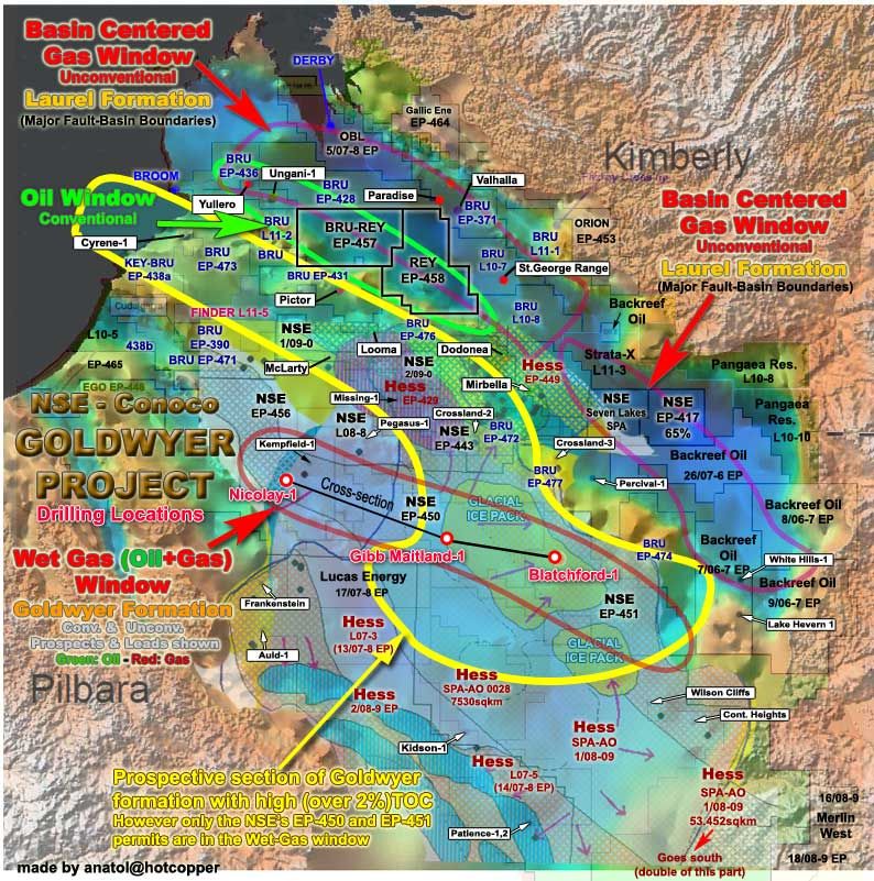
Ice Packs were also located in this area. Therefore, there could be some kind of Late Ordovician Glaciogenic Reservoir Plays in this area
I have posted with late Ordovician glaciogenic reservoir plays on 07/03/2012. “Late Ordovician Glaciogenic Reservoir Plays”
GIBB MAITLAND AND BLATCHFORD LOCATIONS:
- Late Ordovician Glaciogenic Reservoir Plays
- Potential to be giant oil & gas fields
I have found out that the area where NSE’s Gibb Maitland and Blatchford Locations will be drilled, is on Crosland Platform at north of Kidson sub-basin where very large ice packs stayed there millions of years during and after the Late Ordovician glaciation. Therefore it could have glaciogenic reservoir plays. These plays might end up by finding major O&G resources.
It is said on page 60 of SRK Consulting Report “Canning Basin project 1998” (which is made for Shell) ; “While the onset of glaciation is difficult to assess from sediments in the Fitzroy Trough, age-equivalent facies in the Willara and Kidson Sub-basin are clearly of a glaciogenic origin”.
Add to My Watchlist
What is My Watchlist?

