Their 758 mmb's is basically Prospective Unrisked Gross Rec oil resource estimate.
One applies a GCoS of say 20-25% to this & then the Operator's net share. To that figure u can initially attribute a USD 1-2/bbl to get a risked valuation. The SP will never reflect this & so it serves as a basic guideline for Analysts.
Just briefly, CoS is a Combination of 5 key variables that one infers from the seismic data, geological history of the acreage, vintage drilled wells, any cores/sidewall core data & DST results.
Essentially one identifies, a reservoir, source, seal, trap, pathways & assigns a percentage to each.
Multiply all those variable & u get your CoS. Multiply this by a DHI to get a GCoS. See example below.
(eg: chances of reservoir: say 80%, source: 60%, seal 80%, trap 60% each, Maturation 90%, so the CoS in this case is 80% * 60% * 80% *60%*90%= 20% CoS)
Then, depending on how their 2D/3D seis is for a 'Lead' u look at any signs of Direct Hydrocarbon Indicators (ie flatspots, porous rocks filled with fluids incl water will light up more then non-porous or tight rocks).
So the CoS is then multiplied by a DHI multiple to get a final GCoS (ie geological chance of success). This factor is also known as a Risk factor. It's a complicated subject & I wont go into the details.
----------------
Re: yr question on Alpha & its flow et al.
If the conventional formation is of a different age (younger) then the Shale at IW#1 & it flows say for argument sake 200 bopd then one can chase it by remapping the seismics around the vicinity of the well head. That result will reflect the confidence for that particular horizon (say from depth 2800-2850m as an example only) around the well, not across the entire Acreage.
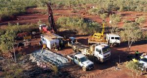
Challenge for 88E is that the 2 wellbores at Franklin Bluff & West Kadler r too shallow so they are shooting their own 2D & mapping out New Leads/prospects.
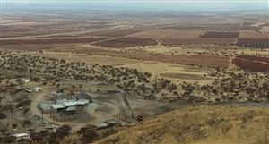
West Kadleroshik is apprx 8.4 Kms NE from Frnk Blf & was drilled by Mobil in 1974 till a depth of 4566 ft. Had 2 DST's done at shallow depth. So the NE end of Alpha gets closer to this well.
Co-ordinates (Lat/Long) for IceWine#1 pad are roughly 69.71722, -148.70281. Just copy & drop these in Google Earth for a flyby of the pad. WK is 8.4 kms NE from here across the river.
I have to rush out now, time to explore an Lava flow for the wkend. Hope the above helps.
Do chkout OEL's (otto) slideshow dt 13th Sept, they've shown their CoS. I think 88E should do that in due course. Cheers.
A personalised tool to help users track selected stocks. Delivering real-time notifications on price updates, announcements, and performance stats on each to help make informed investment decisions.


 (20min delay)