Below is the relevant section copied from the DEG Quarterly report. I found it interesting.
Conglomerate Gold
Following the discoveries of numerous surface gold nuggets made near Karratha by Novo Resources Corporation and Artemis Resources, and Novo’s associated “land grab” in the region that resulted in them acquiring tenements around De Grey’s tenure, De Grey undertook a project wide review of its tenure. This review in the first instance identified and defined a large target area of prospective Fortescue group rocks in the same stratigraphic position that hosts the Novo/Artemis discoveries.
The review identified two significant areas of Mt Roe Basalt, being Louden’s Patch and a 12 km zone, both to the western end of De Grey’s tenure, and on the Indee tenements that remain the subject of an option agreement. These two areas are shown in the map below.
Diagram Three – Map showing Conglomerate Gold Targets at western end of De Grey’s tenure
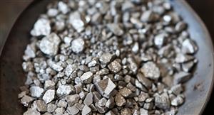
Mapping, sampling and metal detecting commenced for conglomerate hosted gold in these two areas, with Louden’s Patch providing immediate results, identifying outcropping conglomerates at the base of Mt Roe Basalt. This was followed up by the metal detection of 91 nuggets downslope from shallow dipping to flat lying conglomerate, many flattened “watermelon seed” shaped nuggets with pitted texture. The target size of the conglomerate zone shows a 1.0km strike x 400m width x 5-10m thick.
Diagram Four - Eight (8) of the 91 gold nuggets indicating the potential at Louden’s Patch
9 | Page Quarterly Activities Report – June 2017
This work was then followed up with mapping and metal detecting at the 12 km zone which also revealed significant strike lengths of conglomerates and similarly shaped watermelon seed nuggets, at Jarret and Steel Well.
Diagram Five – Conglomerate Gold Targets within the 12 km zone
10 | Page Quarterly Activities Report – June 2017
Diagram Six - Jarret Well gold nuggets showing pitted nature where sand grains have been imprinted during burial.
Diagram Seven - Waterworn gold nuggets found 500m south of Steel Well Conglomerate
Interpretation of mapping, geophysics data and aerial photography indicates the Jarret Well and Steel Well Conglomerates represent the same large and continuous unit some 50-80m thick, shallowly dipping beneath the Mt Roe Basalt. This provides a continuous target over 2.5km in strike length and with considerable thickness. The prospective area beneath the Mt Roe Basalt represents an area of approximately 10km2 providing a large down dip target. 7
Ann: Whim Creek Project Gold Update, page-70


Add DVP (ASX) to my watchlist
 (20min delay) (20min delay)
|
|||||
|
Last
$2.04 |
Change
-0.040(1.92%) |
Mkt cap ! $526.4M | |||
| Open | High | Low | Value | Volume |
| $2.05 | $2.08 | $2.00 | $924.4K | 453.5K |
Buyers (Bids)
| No. | Vol. | Price($) |
|---|---|---|
| 1 | 10000 | $2.02 |
Sellers (Offers)
| Price($) | Vol. | No. |
|---|---|---|
| $2.07 | 9353 | 2 |
View Market Depth
| Last trade - 16.10pm 19/07/2024 (20 minute delay) ? |
| DVP (ASX) Chart |