see where there is an announcement on AIM today but not yet on the ASX releases. see below
Company Forte Energy NL
TIDM FTE
Headline Initial RC Drilling Results at Mauritaniun Uranium Prospects
Released 14:13 26-Jul-2010
Number XUK6246185
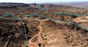
FORTE ENERGY NL ACN 009 087 852 ASX/AIM CODE: FTE Telephone: +618 9322 4071, Fax: +618 9322 4073 ASX, AIM and Media Release 26 July 2010 New mineralisation and additional targets identified in initial drilling at Mauritanian uranium prospects Preliminary results of reconnaissance drilling from four uranium anomalies - Preliminary results received from four locations (Beso, Bir En Nar, M52 and M60) from within the southern sections of Forte Energy's exploration licences in northern Mauritania. These assays are part of a 5000m program of short-hole Reverse Circulation ("RC") drilling targeting 10 uranium anomalies - The results provide further confirmation of the potential of the Reguibat Craton in Northern Mauritania to be a significant new uranium province. Forte Energy has first mover advantage in this province with an extensive ground position covering key lineaments - Highly prospective Beso anomaly 5km south-west of Bir En Nar identified for further drilling following high- grade chemical assays including: -- BSRC10: 2m @ 1283 ppm Uranium -- BSRC12: 6m @ 537 ppm U -- BSRC18: 17m @ 1166 ppm U -- BSRC19: 15m @ 813 ppm U -- BSRC21: 16m @ 776 ppm U - New zone of uranium mineralisation identified at Bir En Nar between existing North and South zones with assays including 3m @ 1027 ppm U. Further drilling planned for possible incorporation into recently announced initial JORC resource - Uranium mineralisation confirmed at M52 and M60 with best assays including: -- M52RC02: 5m @ 524 ppm U -- M52RC07: 1m @ 667 ppm U -- M60RC01: 9m @ 533 ppm U -- M60RC03: 12m @ 359 ppm U - Assay results from the remaining six anomalies drilled in the northern sections of the licence areas to be released when available International uranium company Forte Energy NL (ASX/AIM: FTE; "Forte Energy" or "the Company") is pleased to advise that the initial results from its 5000m short hole RC reconnaissance drilling program has identified additional mineralisation and new targets for follow-up exploration. Drilling was conducted across 10 uranium prospects within the Company's 100%-owned uranium exploration licences in the Zednes region of northern Mauritania, West Africa. Chemical assay results have so far been received from four of those prospects, all located in the southern part of the licence areas: Bir En Nar, BESO, M60 and M52. The uranium mineralisation at all four of these prospects is mainly hosted in breccias and alteration zones within broader shear / fault zones in the regional granite bedrock. Figure 1 - Forte Energy's exploration permits in Mauritania (Please open the following link in a new window to view) media3.marketwire.com/docs/forte_fig1.pdf Bir En Nar RC drilling 2010 Two uranium zones are well known in Bir En Nar, the main North Zone and the South Zone. In between those zones, two small lenses of anomalous radioactivity were found. Four RC holes were drilled on these lenses. Two of these holes encountered uranium bearing zones. In BNR42, four metres with an average grade of 352 ppm U was intersected. BNR44 included 3 metres with an average grade of 1027 ppm U. Additional RC drilling is planned for H2 2010 to explore this mineralisation further. On 19th July 2010 Forte Energy announced an initial JORC compliant Indicated and Inferred Resource of 1.33Mt @ 704ppm U3O8 for 2.06Mlbs of contained U3O8 (100ppm cut-off), comprising an Indicated Resource of 0.55Mt @ 886pm U3O8 for 1.07Mlbs of contained U3O8 and an Inferred Resource of 0.78Mt @ 575pm U3O8 for 0.99Mlbs of contained U3O8. When estimating the initial JORC resource for Bir En Nar, the independent consultant did not use the results from the gamma logging carried out in conjunction with the initial 2007 RC drilling programme. Future work being planned at Bir En Nar includes additional drilling to verify this data which we believe will increase both the tonnage and the grade of the deposit. Drilling will also test for extensions to the main mineralised zones which remain open at depth in several areas. Figure 2 -Exploration targets within Forte Energy's Mauritania permits (Please open the following link in a new window to view) media3.marketwire.com/docs/forte_fig2.pdf Beso Prospect Beso Project is located 5km south-west from the Bir En Nar Project, along a SW-NE trending fault/shear zone that is highlighted by a 500m-wide zone of "red" alteration. The red colour of this type of alteration at Beso and the other prospects is most likely caused by a hematitisation process of the granite. Some of the strong red alteration rock has up to 10 % iron content compared to normal rock where iron is present up to 3 %. Such alteration is an indication of both favourable pathways for fluid flows, as exist within shear/fault zones, and also of potentially favourable conditions for the deposition of uranium mineralisation. The radiometric anomaly consists of several narrow but strongly radioactive alignments along a 3km long zone. The radioactive alignments are mostly orientated in a SW-NE direction or disposed in an E-W diagonal direction. The majority of the radioactive alignments are inside an area delineated by two parallel SW-NE structural alignments spaced at 600m distance. All the radioactive alignments are linked with the pervasive red alteration. Forte Energy previously excavated six trenches totalling 804 metres using a D 9 bulldozer on the NW side of the project. The trenches are orientated N-S or E-W. A total of 36 grab samples were collected from the trenches for assaying and 32 of the samples returned values higher than 85 ppm uranium (equivalent to 100ppm U3O8) with a maximum of 1280 ppm U along a 5m section of trench 4. The assay result distribution generally corresponded with the radioactive alignments and suggested that the uranium mineralisation is disposed in two zones and is strongly linked with the red alteration. In 2010, following up a previous airborne survey, Forte Energy undertook vehicle-mounted radiometric and ground scintillometer surveys which identified alignments along another 2.5km in the SW extension from the known anomaly. In March 2010 drilling of 33 RC holes totalling 862 metres was carried out. A total of 22 vertical holes were drilled at the NE end of the project. The holes were situated on the radiometric peaks of the ground scintillometer survey. A set of 11 angle holes were drilled to investigate some of the radiometric alignments on the remaining SW extension. A total of 394 one-metre samples were sent for assaying. Of these, 259 samples returned values greater than 85 ppm U with a maximum of 2164 ppm U. Four lithological units have been identified based on surface observation and RC chip logging: regional granite, granitic dykes, breccia and granite with quartz veins. Regional granite, represented by granite with biotite and hornblende, covers the largest area of the prospect. According to the PRISM geology it is part of the Proterozoic Gleibat Tenebar Group (2073 MY). This granite is intruded in the prospect area by a series of dykes or small bodies of medium grain size feldspatic granite. Most of these intrusions are orientated E-W or NW-SE. Breccia is present as narrow bodies and disposed mostly along the SW-NE trend. There are two types of breccia. At the NE end of the prospect there is a dark red massive breccia with little visible quartz. This type of breccia seems to be the most favourable for the uranium mineralisation. The second type of breccia is located along the SE structural alignment and displays a banded mylonitic mode with the quartz layers alternating with red dark less quartzitic layers. Along the structural alignments in SW-NW and E-W a pervasive red alteration is present and has a direct link with uranium mineralisation. The mineralisation is disposed in parallel subvertical layers dipping SE, along two structural alignments orientated SW-NE and E-W. It is hosted in breccia, red altered granite and in granite with quartz veining. The NE end of the prospect offers the best intersections in an area where the two main structural directions intersect. Figure 3 -RC Drillhole cross sections from Beso (Please open the following link in a new window to view) media3.marketwire.com/docs/forte_fig3.pdf Figure 4 -RC Drillhole locations at Beso (Please open the following link in a new window to view) media3.marketwire.com/docs/forte_fig4.pdf Table 1. Mineralised intervals from drillhole assays at Beso ----------------------------------------------------- Hole ID From To Interval (m) U ppm Type ----------------------------------------------------- BSRC01 0 11 11 202 Vertical ----------------------------------------------------- BSRC01 12 17 5 242 Vertical ----------------------------------------------------- BSRC02 0 18 18 350 Vertical ----------------------------------------------------- BSRC02 19 28 9 362 Vertical ----------------------------------------------------- BSRC03 0 4 4 249 Vertical ----------------------------------------------------- BSRC04 0 2 2 408 Vertical ----------------------------------------------------- BSRC05 0 1 1 162 Vertical ----------------------------------------------------- BSRC05 5 7 2 175 Vertical ----------------------------------------------------- BSRC06 0 2 2 113 Vertical ----------------------------------------------------- BSRC06 5 6 1 353 Vertical ----------------------------------------------------- BSRC06 7 10 3 369 Vertical ----------------------------------------------------- BSRC06 11 17 6 218 Vertical ----------------------------------------------------- BSRC07 0 5 5 433 Vertical ----------------------------------------------------- BSRC07 8 9 1 642 Vertical ----------------------------------------------------- BSRC08 0 7 7 240 Vertical ----------------------------------------------------- BSRC09 10 20 10 270 Vertical ----------------------------------------------------- BSRC09 4 6 2 150 Vertical ----------------------------------------------------- BSRC10 0 2 2 1,283 Vertical ----------------------------------------------------- BSRC11 1 2 1 206 Vertical ----------------------------------------------------- BSRC12 0 6 6 537 Vertical ----------------------------------------------------- BSRC12 7 9 2 99 Vertical ----------------------------------------------------- BSRC12 15 24 9 362 Vertical ----------------------------------------------------- BSRC12 26 27 1 257 Vertical ----------------------------------------------------- BSRC13 0 4 4 523 Vertical ----------------------------------------------------- BSRC13 5 6 1 116 Vertical ----------------------------------------------------- BSRC13 7 11 4 182 Vertical ----------------------------------------------------- BSRC13 14 16 2 196 Vertical ----------------------------------------------------- BSRC14 0 3 3 257 Vertical ----------------------------------------------------- BSRC14 6 8 2 370 Vertical ----------------------------------------------------- BSRC15 0 6 6 100 Vertical ----------------------------------------------------- BSRC17 12 13 1 131 Vertical ----------------------------------------------------- BSRC17 14 18 4 247 Vertical ----------------------------------------------------- BSRC18 0 17 17 1,166 Vertical ----------------------------------------------------- BSRC19 0 15 15 813 Vertical ----------------------------------------------------- BSRC19 18 20 2 113 Vertical ----------------------------------------------------- BSRC19 21 23 2 209 Vertical ----------------------------------------------------- BSRC20 0 22 22 477 Vertical ----------------------------------------------------- BSRC21 0 16 16 776 Vertical ----------------------------------------------------- BSRC22 0 3 3 297 Vertical ----------------------------------------------------- BSRC22 7 9 2 166 Vertical ----------------------------------------------------- BSRC22 12 24 12 341 Vertical ----------------------------------------------------- BSRC22 25 32 7 244 Vertical ----------------------------------------------------- BSRC23 10 12 2 358 Angle ----------------------------------------------------- BSRC23 15 18 3 135 Angle ----------------------------------------------------- BSRC24 12 14 2 295 Angle ----------------------------------------------------- BSRC24 18 19 1 157 Angle ----------------------------------------------------- BSRC25 13 14 1 136 Angle ----------------------------------------------------- BSRC27 19 20 1 151 Angle ----------------------------------------------------- BSRC28 16 17 1 172 Angle ----------------------------------------------------- BSRC28 28 33 5 355 Angle ----------------------------------------------------- BSRC28 35 36 1 123 Angle ----------------------------------------------------- BSRC28 39 40 1 114 Angle ----------------------------------------------------- BSRC28 41 42 1 219 Angle ----------------------------------------------------- BSRC29 7 10 3 113 Angle ----------------------------------------------------- BSRC30 41 43 2 189 Angle ----------------------------------------------------- BSRC31 30 31 1 110 Angle ----------------------------------------------------- BSRC32 4 5 1 146 Angle ----------------------------------------------------- BSRC33 39 41 2 437 Angle ----------------------------------------------------- A more systematic follow up of the high-grade area in the NE with core and RC drilling is planned to commence this year. A study of the mineralogy is currently underway. M60 Prospect The M60 Project is located 3km SE of the Bir En Nar Project, along a SW-NE trending fault / shear zone that is highlighted by a 200m to 500m wide zone of red alteration. Along this zone a set of other radiometric anomalies are also located including BESO, M54, M61, M62 and M64, identified from previous work by Minatome. The radiometric anomaly is very narrow at the surface consisting of one line of points with high radiation values of up to 1000 counts per second (cps) on an SSP2 scintillometer instrument. A set of four trenches at about 50m intervals, totalling 172m in length, were dug using an excavator in October 2009 along the anomalous trend. The trenches intersected a 5m to 12m wide breccia zone with anomalous cps values. A total of 41 one metre channel samples were assayed and 19 samples returned values greater than 85 ppm U with a top value of 620 ppm U. Seven RC holes were drilled in February 2010, totalling 370m. They are disposed on six profiles covering 250m of strike. A total of 159 one metre samples were selected for assaying, of which 80 samples returned assay results greater than 85 ppm U with the highest value of 1253 ppm U. Figure 5 -RC Drillhole locations at M60 (Please open the following link in a new window to view) media3.marketwire.com/docs/forte_fig5.pdf Table 2. Mineralised intervals from drillhole assays at M60 -------------------------------------------- Hole ID From To Interval (m) U ppm -------------------------------------------- M60RC01 15 16 1 143 -------------------------------------------- M60RC01 17 26 9 533 -------------------------------------------- M60RC01 38 39 1 236 -------------------------------------------- M60RC01 43 44 1 189 -------------------------------------------- M60RC02 4 6 2 264 -------------------------------------------- M60RC02 10 21 11 249 -------------------------------------------- M60RC02 36 37 1 194 -------------------------------------------- M60RC02 39 40 1 88 -------------------------------------------- M60RC03 7 19 12 359 -------------------------------------------- M60RC03 20 21 1 253 -------------------------------------------- M60RC03 22 24 2 260 -------------------------------------------- M60RC03 25 27 2 428 -------------------------------------------- M60RC03 28 32 4 260 -------------------------------------------- M60RC03 39 40 1 128 -------------------------------------------- M60RC04 7 10 3 289 -------------------------------------------- M60RC04 12 13 1 296 -------------------------------------------- M60RC04 41 43 2 181 -------------------------------------------- M60RC05 5 12 7 352 -------------------------------------------- M60RC06 18 27 9 166 -------------------------------------------- M60RC06 28 29 1 93 -------------------------------------------- M60RC07 36 40 4 346 -------------------------------------------- M60RC07 42 43 1 228 -------------------------------------------- M60RC07 45 46 1 101 -------------------------------------------- M60RC07 53 54 1 174 -------------------------------------------- M60RC07 59 60 1 89 -------------------------------------------- Three lithological units are present in the drillholes: regional granite, granite with quartz veins and breccia. Outside of the drilled area various types of granite, pegmatite, granitic dykes and breccia have been reported. Regional granite includes different granitic composition with different types of alteration (partial pink alteration affecting mostly the feldspar to strong pervasive red alteration that changed the initial composition by dequartzification and albitisation of the initial composition). Granite with quartz vein flanks the breccia on the both sides and probably is a result of the dequartzification process. The quartz is mostly disposed in narrow veins that are parallel with the mineralisation. The breccia is a red fine grain fractured rock. It has been mapped as such when a granitic structure could not be identified. There are two types of breccia: a breccia without visible quartz and a breccia with quartz veins. Usually the breccia without visible quartz is located in the central part of the structure and is the most favourable for uranium mineralisation. The mineralisation is disposed in some parallel bodies along the strike of the fault/shear zone. The main mineralised body with one or two mineralised zones is located in the central part of the structure and is linked with breccia zone. Also on each side of the breccia, in the granite with quartz veins, occur minor mineralised bodies apparently in the areas where the frequency of the quartz veins is decreasing. No further work is planned at this time for M60. Figure 6 -RC Drillhole cross section from M60 (Please open the following link in a new window to view) media3.marketwire.com/docs/forte_fig6.pdf M52 Prospect The M52 prospect is located 23km NW from Bir En Nar, along a WNW -ESE trending fault/shear zone highlighted by a 200m wide zone of red alteration. The radiometric anomaly comprises high radiation points recording up to 20,000 cps on an SGR-GF scintillometer, linked to small breccia outcrops disposed along a fault zone. The anomaly was located in the field during February 2010. A scintillometer ground survey to identify the higher cps zones was carried out. A target zone about 700m long was selected for a preliminary RC drilling program. Seven holes disposed on five drill fences, totalling 339 metres were drilled in March 2010. 79 one metre RC samples were selected for assaying. Of these, 23 samples returned assay values greater than 85 ppm U with a maximum of 875 ppm U. Table 3. Mineralised intersections from drillhole assays at M52. ------------------------------------------ Hole ID From To Interval (m) U ppm ------------------------------------------ M52RC02 15 16 1 121 ------------------------------------------ M52RC02 17 19 2 147 ------------------------------------------ M52RC02 21 23 2 269 ------------------------------------------ M52RC02 24 29 5 524 ------------------------------------------ M52RC02 46 47 1 122 ------------------------------------------ M52RC04 17 21 4 174 ------------------------------------------ M52RC04 29 30 1 94 ------------------------------------------ M52RC05 27 28 1 202 ------------------------------------------ M52RC06 8 10 2 302 ------------------------------------------ M52RC06 17 18 1 281 ------------------------------------------ M52RC06 21 22 1 135 ------------------------------------------ M52RC07 15 16 1 116 ------------------------------------------ M52RC07 24 25 1 667 ------------------------------------------ Figure 7 -RC Drillhole cross section from M52 (Please open the following link in a new window to view) media3.marketwire.com/docs/forte_fig7.pdf Four lithological units were identified: regional granite, sheared granite, mylonite and breccia. The regional granite is represented by a coarse to very coarse grained granite with biotite and hornblende. It is part of Adam Esseder Proterozoic Group according to PRISM geology. The fault/shear comprises sheared granite, mylonite and breccia. The sheared granite is medium grained with visible quartz and feldspar included in an envelope of epidote and chlorite. The mylonite is represented by a fine grained green rock with a strong fabric. The breccia is massive, fine grained, stained dark red or green with some high radioactive outcrops at the surface. The uranium mineralisation is disposed almost exclusively in the breccia forming subvertical discontinued parallel layers dipping to south along the fault / shear zone. No further work is planned at this time for M52. Forte Energy is pleased with the initial results from the RC drilling of targets in the southern part of its exploration licences. The Company is looking forward to receiving the results from the remaining six anomalies tested from the northern sections of its licences as it finalises plans for follow-up drilling programs. Mark Reilly Managing Director For further information contact: Mark Reilly, Managing Director Forte Energy N.L. Tel: +44 (0) 203 300 0187 Alastair Stratton/Tim Graham Matrix Corporate Capital LLP Tel: +44 (0) 203 206 7000 Conduit PR Jos Simson/Emily Fenton Tel: +44 (0) 207 429 6603 Nichlas Read/Paul Armstrong Read Corporate Tel: +61 (0) 8 9388 1474 Stuart Laing RFC Corporate Finance Ltd Tel: +61 (0) 8 9480 2506 (AIM Nominated Adviser to the Company) Note: The Mineral Resource at Bir En Nar is based on information compiled by Mr. Bosse Gustafsson who is employed by Forte Energy NL and Mr. Neil Inwood who is employed by Coffey Mining Ltd. Mr. Gustafsson and Mr. Inwood have sufficient experience which is relevant to the style of mineralisation and type of deposit under consideration and to the activity which they have undertaking to qualify as a Competent Person as defined in the 2004 Edition of the "Australasian Code for Reporting of Mineral Resources and Reserves". Mr. Gustafsson is a member of the European Federation of Geologists a Recognised Overseas Professional Organisation ("ROPO"). Mr Bosse Gustafsson is a full time Technical Director of Forte Energy NL and is responsible for exploration activities in Mauritania and Guinea. Mr. Gustafsson and Mr. Inwood consent to the inclusion in this report of the matters based on their information in the form and context in which it appears. Forte Energy NL


Add to My Watchlist
What is My Watchlist?