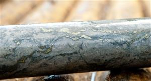
Obviously depending on how much area they are surveying the actual scanning with LIDAR is relatively fast.
They then need to upload thousands of data points, model it and analyse it etc. Potentially there could be areas they want to revisit/fly over again with different parameters/laser strength.
It doesn't sound too complicated, but factor in the topography/Brazilian terrain and size of the tenements and it could take days just getting around the tenement to setup for mapping.
I agree we should see a LIDAR announcement soon, they had started weeks ago then in one of the announcements mentioned they had extended the program.
GLTAH
Obviously depending on how much area they are surveying the...


Add SUM (ASX) to my watchlist
 (20min delay) (20min delay)
|
|||||
|
Last
19.5¢ |
Change
-0.010(4.88%) |
Mkt cap ! $14.73M | |||
| Open | High | Low | Value | Volume |
| 21.0¢ | 21.0¢ | 19.0¢ | $79.54K | 401.5K |
Buyers (Bids)
| No. | Vol. | Price($) |
|---|---|---|
| 2 | 66504 | 19.5¢ |
Sellers (Offers)
| Price($) | Vol. | No. |
|---|---|---|
| 20.0¢ | 50512 | 4 |
View Market Depth
| Last trade - 11.53am 29/07/2024 (20 minute delay) ? |
| SUM (ASX) Chart |