Mukabe-Kasari Cobalt-Copper Project Exploration Update III
RMX delineates extensive geochemical copper anomaly at the Mukabe-Kasari Cobalt-Copper Project
New copper anomaly extends over a strike length of more than 12 km, and has been confirmed over three zones of geochemical sampling
Copper anomalies occur at several elevations suggesting multiple mineralised horizons
Scout drilling for cobalt mineralisation has not yet returned results sufficient to sustain a commercial cobalt operation
Red Mountain Mining Limited (the Company, Red Mountain or RMX) provides the final results of its maiden 2017 exploration program at the Mukabe-Kasari Cobalt-Copper project in the DRC.
The Mukabe-Kasari Cobalt-Copper project area is a greenfields exploration play situated approximately 250 km northwest of Lubumbashi, and about 70 km north of the giant Tenke-Fungerume Copper-Cobalt mine. It comprises 17 artisanal licenses covering approximately 130 km2. For further detail on the region and nearby cobalt and copper mines, see the RMX announcement released on 21 March 2017.
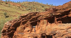
The Mukabe-Kasari Cobalt-Copper project was considered prospective because of its multiple showings of copper mineralisation and its proximity to major mining localities. The area occupies the slopes of the Katanga Plateau (Figure 1 and Figure 2). The bed rock consists of sedimentary strata of the Upper Nguba and Lower Kundelungu Formations which are gently folded in the project area and consist of siltstones, sandstones and calcareous siltstones (Figure 2). Secondary copper-cobalt mineralisation (malachite, azurite, chalcocite), occurring as layer-parallel horizons of disseminated secondary (malachite and azurite) and transitional copper (chalcocite, bornite) mineralisation. Mineralisation was mapped at several locations in the project area.
Figure 1: Mukabe-Kasari property location map and extent of surface geochemistry and RAB drilling.
Figure 2: 3D diagrammatic illustration of the geological setting and target areas. Based on reconnaissance work, the Mukabe-Kasari area is prospective for stratiform copper mineralisation. The diagram represents a 3D view the project area and shows gentle folded strata of the Nguba / Kundelungu Formations that host seams of stratiform copper mineralisation. Contours of anomalous geochemical copper samples are shown as coloured outlines. (Vertical exaggeration 1:10, for actual locations and sample grade ranges refer to Figure 3).
Exploration Work Completed
The surface geochemical program was centred around areas of outcropping copper mineralisation and a total of 657 samples were collected across three areas (Figure 1). The samples comprise soil and rock chip samples collected on a 200 by 100 m grid (Figure 1, Figure 3).
Soil samples were collected between 30 and 70 cm below the organic rich top soil layer. About 2 kg of bulk material was collected from each sample site. About the same volume of weathered rock was collected where bed rock was at surface.
Areas of geochemical sampling (either soil and rock chip sample, depending on sample site), were followed- up by a small number of shallow pits to establish the vertical extent of mineralised horizons, if possible the number of mineralized beds, and the thickness of individual beds.
Inset-1
Inset Area-1
Inset Area-2
1,000m
Inset-2
1,000m
Figure 3: Interpreted geochemical results for the all geochemical sampling grids. Map shows contoured percentile ranges. Results are plotted on elevation background (see Figure 2 for elevation ranges ).
The geochemical results and geological observations strongly suggest that the copper mineralisation occurs as laterally extensive horizons, possibly several kilometres in strike extent if individual occurrences at a similar elevation are connected.
The topography of the project area rises to the northwest (Figure 3), suggesting that anomalies at different elevation in an area of sub-horizontal layering are possibly related to different layers of the stratigraphy, possibly indicating multiple layers with mineralisation. The spacing, thickness and grade of these different layers needs to be tested. Drilling will be required to establish the thickness and lateral extent of any mineralisation.
Analysis and Results
Analytical results have been received for all batches submitted to the laboratory and include 659 sample assay results (Figure 3). Inset 1 and 2 in Figure 3 show contoured results for copper for the central and northern sampling grids. The map shows percentile contours of both samples types. (Figure 3, Inset 1 and 2).
Anomalous copper values range up to 730 ppm Cu in rock chips and 810 ppm Cu in soils samples and correlate with zinc, silver and elevated cobalt values. Table 1 presents the sample results from the upper percentile ranges, represented by the yellow / orange/red contours in Figure 3.
The upper percentile ranges (greater than 148 ppm Cu) for both soil and rock chip values overlap when contoured identifying multiple anomalous area of up to 3 km2 and confirm the robustness of the anomaly. The anomalies interpreted, are broadly parallel to the sub-horizontal strata and are observed, at a project scale, to occur at multiple elevations (Figure 3).
These copper results are encouraging as they confirm:
1. The potential for in-situ copper mineralisation,
2. Multiple horizons of stratiform copper mineralisation 3. Laterally extensive anomalism, and
4. A regional effective mineralisation system.
The results are expected to support the planning of a targeted drill testing campaign to determine the thickness and spacing of the mineralised horizons. However, this will be evaluated in the context of the overall risk profile of the project, pre-season mapping results and the other opportunities that may become available to the Company.
The RAB drilling carried out which focussed on potential cobalt mineralisation did not yield significant results. While anomalous levels of cobalt were detected across a meaningful area within the project area, such levels are insufficient to sustain a commercial cobalt operation.
RMX Price at posting:
3.1¢ Sentiment: Buy Disclosure: Held
A personalised tool to help users track selected stocks. Delivering real-time notifications on price updates, announcements, and performance stats on each to help make informed investment decisions.


 (20min delay)