Further to that report from INV metals that you posted. I have attached a map showing a new 'mineralised trend?" and i have drawn the boundaries of the EPL 4346 (existing) EPL 4540 (CLA acquisition) and EPL 4541 which gets a write up on pages 91, 92 and 93.
I also referenced where drill holes 1 and 2 are. marked with a cross on the top of the page
I don't know how relevant it is but as he is a CLA fan your Geo might be interested in this.
Cut and Paste from the report
pp91
9.2.2. INV Metals Staked Claims
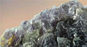
A brief field assessment of licences EPL4540 – 45 and 4557 (see Figure 9-1 for claim locations attached on the initial email) was undertaken by INV Metals geologists in September 2011. On the maps, main units of significance are Nosib Formation (orange and brown), Lower Omao (light blue) and Upper Omao (darker blue), and basement (pink).
EPL 4540- The license is located roughly 35 kilometres north-northwest of Opuwo almost solely within river drainage immediately south of Onyarakaha Mountain. Access is generally good along unmaintained dirt tracks that run throughout and immediately north of the license. The EPL is located within the Steilrandberg Syncline, north of the Opuwo Lineament, along the northern boundary of the Neoproterozoic Opuwo Inlier of the Kaoko Belt. It is underlain by siliciclastic rocks of the Nosib Group in the south with progressively younger siliciclastics and carbonates of the Ombombo and Abenab Subgroups to the north. Despite the absence of reported copper mineralization in the license area, copper showings have been identified in similar stratigraphic horizons to the east and southeast of the license. Due to the overall lack of outcrop, combined with restriction of the license to a river drainage system, it is recommended that either a regional stream sediment sampling or a regional soil geochemistry program (i.e. one kilometre line spacing with 500 metre sample spacing) be undertaken.
EPL 4541/4542 - Located approximately 16 kilometres west of Opuwo, license 4541 is transected by district road D3703 that passes through the villages of Okarikwa and Orontjitombo. Access is good along the well maintained district road with numerous unmaintained dirt tracks branching off throughout the license area. The claims are located along the eastern boundary of the Neoproterozoic Opuwo Inlier of the Kaoko Belt. Specifically, the license is located along the southern margin, and transects, the Opuwo Lineament, a major
Page 92 of 133
transcontinental shear zone cutting across the Kaokoland Belt. The licenses are reportedly underlain by granitic gneisses of the Khoabedus Group in the southwest and west, with siliciclastic rocks of the Nosib Group localized to the central portion of the license and progressively younger siliciclastics and carbonates of the Ombombo Subgroup restricted to the east.
The EPLs encircle the Otjitombo zinc-lead and Okalikwa copper-silver-gold prospects (Figure 96) to the east, north and west. The Otjitombo zinc-lead ± copper-gold deposit, currently being explored by Namibia East China Non Ferrous (Pty) Ltd., comprises a series of base metal anomalies in hydrothermally altered dolostones located along the contact between the Lower and Upper Omao Formations (?) folded into northeast-striking folds. The known mineralization is 650 metres in length with a dispersion halo over 50-250 metres.
INV Metals discovered two copper showings, Okau and Okau NE, 7.5 kilometres southwest of the Otjitombo deposit. Grab samples carried up to 0.75% and 0.58% copper, respectively. The Okau showing comprises a variably thin (1-4 metres thick), northeast-trending (>450 metres), tectonized (brecciated to sheared), black dolostone exhibiting occasional malachite-staining and enveloped by dark grey schist. In detail, the dolostone consists of a black, micritic, laminated dolomitic rock transected by numerous white, sparry, calcite, tourmaline (?), ferric calcite veins and iron-oxide filled veins and vugs. Located roughly 3.5 kilometres northeast of the Okau prospect, the Okau NE prospect comprises crackle to mosaic brecciated, milky white quartz and iron quartz veined Nosib Group rocks and brown to tan, dolostone beds enveloped by a dark grey schist and cross-cut by veins (± iron oxides, malachite and sulphides) that share numerous similarities with the Okau prospect. It is interpreted that the Okau showings might represent a southwesterly continuation of the Otjitombo prospect.
This area clearly has excellent potential and requires further exploration leading up to a drill program
Ann: Trading Halt, page-29


Add CLA (ASX) to my watchlist
 (20min delay) (20min delay)
|
|||||
|
Last
1.1¢ |
Change
0.001(5.00%) |
Mkt cap ! $24.27M | |||
| Open | High | Low | Value | Volume |
| 1.0¢ | 1.1¢ | 1.0¢ | $2.436K | 243.6K |
Buyers (Bids)
| No. | Vol. | Price($) |
|---|---|---|
| 6 | 4250853 | 1.0¢ |
Sellers (Offers)
| Price($) | Vol. | No. |
|---|---|---|
| 1.1¢ | 8741140 | 16 |
View Market Depth
| Last trade - 13.15pm 07/06/2024 (20 minute delay) ? |

|
|||||
|
Last
1.0¢ |
Change
0.001 ( 0.00 %) |
||||
| Open | High | Low | Volume | ||
| 1.0¢ | 1.0¢ | 1.0¢ | 126762 | ||
| Last updated 13.35pm 07/06/2024 ? | |||||
| CLA (ASX) Chart |