IS THIS RIGHT @Ya Its not my intelligence,,, Credit to http://www.geomore.com
Seismic
Seismic is one of the most important tools available to the petroleum geologist. It is a method used to determine the depth and orientation of rock formations without actually having to drill a well.
Although the working mechanics of seismic are extremely complicated, the concept is simple.
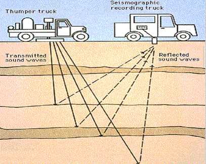
2D Seismic On Land
The Seismic Process
A source of energy is applied at the surface of the ground. This energy may be applied by a thumper truck, which uses a large, heavy iron plate to strike the ground. Sometimes, the source will be dynamite, placed in a shallow hole and exploded.
Sound waves from the source travel down into the ground and are reflected back by the rock layers back up to the surface. A system of listening microphones, or geophones, pick up the reflected sound waves. The simple picture shown here shows only one receiver. In practice, many such receivers are used at once. The more receivers used, the better the quality of the received data.
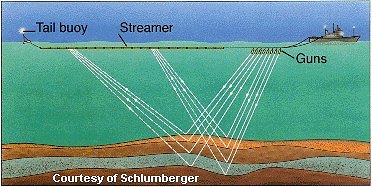
2D Seismic On The Ocean
In a similar way, seismic data can be acquired for the sea floor and the rock layers beneath the sea.
Marine Seismic
To do this, a ship at sea tows a seismic source behind it. The seismic source provides very strong waves of sound energy. This energy is often supplied by blasts of compressed air from air guns towed behind the ship. The sound waves penetrate the sea floor. They are then bounced off the rock layers, and are picked up by hydrophones (listening devices located on the streamer) towed behind the ship. The seismic is processed the same way as land seismic.
Seismic Processing
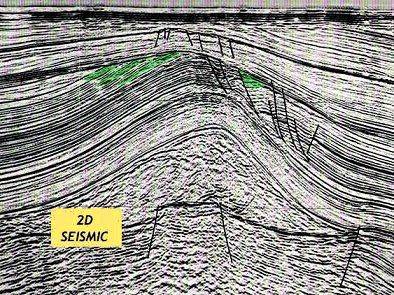
Once the data has all been “shot,” the information is fed into computers for processing. The result is a “line” of seismic, shown below. This seismic could have come from either land or sea acquisition.
A Line of 2D Seismic
This is the oldest type of seismic, and is called “2D” seismic, because the image has an x and y dimension, but no z dimension. In other words, the visual representation is like looking a flat piece of paper. It shows a single cross-section through the earth along a relatively straight line.
Layers of rock deep in the earth can be clearly seen. On this “2D” line, stratigraphic traps containing possible oil or gas have been shaded green.
Computer technology for seismic processing continues to improve. Old seismic can be re-processed using more modern techniques. Re-processing can give a whole new look to old data!
Announcement being made right now, page-20


Add 88E (ASX) to my watchlist
 (20min delay) (20min delay)
|
|||||
|
Last
0.3¢ |
Change
0.001(50.0%) |
Mkt cap ! $86.67M | |||
| Open | High | Low | Value | Volume |
| 0.3¢ | 0.3¢ | 0.2¢ | $10.05K | 3.566M |
Buyers (Bids)
| No. | Vol. | Price($) |
|---|---|---|
| 152 | 214316072 | 0.2¢ |
Sellers (Offers)
| Price($) | Vol. | No. |
|---|---|---|
| 0.3¢ | 581110328 | 194 |
View Market Depth
| Last trade - 16.10pm 12/07/2024 (20 minute delay) ? |
| 88E (ASX) Chart |