Hello,
Came across these pics with captions from Nectar38.
Nectar,
I've added my own cations at the bottom to help you the others get your bearings. These are some very very old photos that were re used by Buffalo and Madison, from their website if I'm not mistaken.
****************************************
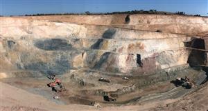
Below is a picture of Mt Kare, a very large mountain range, sticking out of the ground, which would allow for a cheap gold mine. Rather than have to dig into the ground and unearth millions of tonnes of rock, you just tap into the mountain into the areas with the highest grade!
*** Ok, the problem IDC would have mining gold from this mountain is that it's not Mt Kare. What you are looking at here is actually Porgera. This mountain is called Mt Piam, unfortunately its just limestone. The small township in the distance at the base of the mountain is known as Piam Township, this whole area is inside the PJV Exploration Licence. The town in the immediate foreground is called Porgera Station, you can see the original airstrip running through the middle. No longer in use today.
The Pogera mine is located directly outside the right window just out of shot. The watercourse directly out front is the beginning of the Porgera River, this is where the tailings are disposed. This river drops around a thousand feet within a few kms. Mt Kare does not have a river like this for tailings so engineers will need to use other methods
Road access to this area is from the Maip Gap in the top left corner (East). There you will find the Kairik Airstrip. From that location is where helicopters supply the Mt Kare area. From this position which is Mangalap you need to make a right turn on a south heading, avoiding the PJV 'no fly zone' and try to cut through another gap and fingers crossed you will enter into Mt Kare. Fogs is a big problem in the Gap.
***********************************************
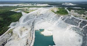
Here is another pic from the other side of the mountain.
*** This is not the other side of the montain. This picture is taken from Mt Kare looking West. To see Mt Kare you need fly over to that mountain and turn around and snap.
Porgera is to the right(North)20 - 30km or 15 - 20 minutes. The creek in front is the Pinnuni Ck. The ground out front belongs to several Clans such as the Yolo, Komai, Leyapi etc. Just in this photo there are around six clan boundaries on the far side of the creek and another four on this side.
To the left (south) out of shot is the remains of the old CRA camp. Directly below in the treeline is where the Madison camp was later constructed. The trees became the building materials so not much there now.
Directly behind and to the right became the N/W Zone.
Paiela (the village that most locals come from) is through the gap on the right then down into the valley. Just left of here is the start of the Southern Clans. These two peoples regions will meet just a short distance left of this position. Further out to the left you are almost seeing the border of the Southern Highlands and Enga Provinces.
Looking further out to the west is nothing until you get to Ok Tedi. This really is the end of the road as they say.
************************************
Below are the powerlines and roads that are already in place near Mt Kare, which feeds the Porgera mine. SO they can run parallel lines for our gold mine.
*** This is taken back out toward Porgera. We are inside the Gap heading back to Porgera. The mine is at the end around to the left, and Mt Piam from the first photo is the mountain at the far end on the right. Out the right window is the Wiley Creek Dam (PJV water supply) along the road you might see the pipeline feeding the mine.
Mt Kare is a left turn and South West 10 minutes. This area is regarded as the border between two regions. Below is the walkng track used by the people but today is just a place to run into raskols and bandits.
The powerline line runs up from the Hides Gas Station from the South. Running a parallel line would be sizable undertaking.
*****************************************
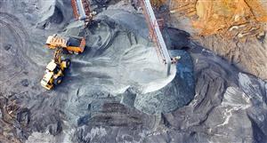
And below is a pic of the NorthWestern Area which contains Roscoelite Gold and Silver. Have a read of the announcement about this gold find from 2006 by Buffalo. Very very exciting!
*** And this is not N/W zone. This is the S/W Zone. This is taken between the time that CRA left and before Madison arrived. The workings are from the locals using the abandoned CRA machines. The original holes were drilled here. This is the area where the all the clans boundaries coincidentaley seem to meet.Hence where all the problems stem from. But you guys don't want to hear about that.
Anyway good luck to you all
************************************
Hello,Came across these pics with captions from Nectar38....


Add to My Watchlist
What is My Watchlist?