"Qualitative Niton Gun analyses coupled with visual inspection of drill samples reveals that the mineralisation previously detected at surface immediately adjacent to the sand volcanoes in the basaltic flow breccias persists laterally in various horizons. Though preliminary, these results are highly encouraging."
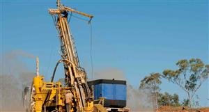
COPPER FLATS – PROGRESS REPORT The recent reconnaissance RC drilling at Copper Flats has been designed to delineate the structure and potential zones of mineralisation associated with a number of highly Cu (copper) mineralised sand volcanoes. The lateral extent of the mineralisation is controlled by the permeability of the basaltic flow breccias immediately adjacent to the sand volcanoes and by joint sets underlying the volcanoes. Some of these mineralised sand volcanoes form along well defined structural corridors that can be followed over distances of several kilometres. Previous surface channel sampling of these and similar mineralised zones in the immediate area of the sand volcanoes indicated extremely Cu rich occurrences which could be traced laterally up to distances of hundreds of metres. Due to the nature of the rugged terrain effective drilling was only achieved by using a special purpose designed in-house drilling system that proved to be highly efficient with a capability of drilling to a depth in excess of 60 metres. Larger, more powerful drilling rigs were not appropriate due to various environmental issues. The application status of certain tenements within the contiguous group of tenements of Ord River Resources (“ORD”) that comprise the Copper Flats Project in the East Kimberley prevented the drilling of the most prospective targets at this time. However, a total of 54 reconnaissance RC holes were drilled on the other anomalous areas. Individual samples for each metre drilled have been dispatched to Australian Laboratory Services (ALS) in Karratha for quantitative analysis for Cu, Pb, Zn and Ag. The complete set of assay results are presently not available, however all results should be available within 6 weeks. Qualitative Niton Gun analyses coupled with visual inspection of drill samples reveals that the mineralisation previously detected at surface immediately adjacent to the sand volcanoes in the basaltic flow breccias persists laterally in various horizons. Though preliminary, these results are highly encouraging. Recent structural mapping, a ground transient electromagnetic (TEM) survey and regional geochemical survey results are currently being compiled together with the drilling data to up-grade ORD targeting of economic scale mineralisation. This important geochemical and geophysical data will be applied to the most prospective areas which will enhance the previously mapped geological components of these structurally complex areas. The trial TEM survey conducted in December 2007 will be fully interpreted by the end of January 2008. This together with the visual re-evaluation of drill cuttings indicates that an airborne TEM survey will be the most effective method of screening surface anomalies. Final compilation of structural mapping data is in progress and will further assist in the ranking of anomalies. This coupled with the interpretation of drainage geochemistry over all granted tenements will be combined with the specific geological data sets to assist in the interpretation and final ranking of mineralisation anomalies Drilling will recommence following a full review of all compiled data. Further field mapping and sampling has been conducted in several different geological and geomorphological environments all of which have the potential to host economic size and grade deposits.
VAN Price at posting:
0.0¢ Sentiment: Buy Disclosure: Held