http://www.cgt.net.au/PDFs/InvestorPresentation5Dec06.pdf
No town over the top, no old workings since they didn't understand the way the gold worked, so only 3 deep mines in the whole field. And the 3D map is now completed and drilling is about to start. Only 12million cap!
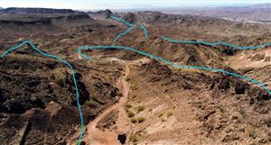
The Castlemaine Goldfield is under-explored
This field is unquestionably under-explored. The figure below shows the concentration of drilling around old mines and the absence of any significant drilling in the north.
Prior to October 2006 there are only 522 holes, of which 355 are diamond and of which 84 are located away from Wattle Gully. These holes have an average depth of 178m.
Why was there relatively little underground mining at Castlemaine
There is no doubt that water ingress, harder rock and shonky deals all contributed to loss of confidence in the field. However these reasons of themselves do not distinguish the Castlemaine field.
We consider that the three major reasons why the Castlemaine field was not developed at depth were:
The wealth of the alluvials - some 3 million ounces were won in the first 10 years of the first mining boom.
Over-use of the Bendigo model - our research has shown an inadequate geological understanding of the major structural controls on gold mineralization. When deeper mining was attempted, in most instances the target was repetitive vertical saddle reefs but saddle reefs formed only a small proportion of the goldfield's past production compared to near surface spur and laminated quartz veins.
Beaten by time - by the time the alluvial fields and shallow workings were worked out, changing economic circumstances and the outbreak of war closed down the remaining mining operations.
Two examples to support our contention that the old miners did not have sufficient understanding of the major structural controls can be seen in the old Ajax and Quartz Hill mines.
The Bolivia shaft had early success at shallow depth on a west dipping fault. Using the Bendigo model, capital was raised to sink deeper looking for the next repeat. A number of levels were developed from the Ajax shaft with cross-cuts into "centre country". The poor returns from deeper prospecting resulted in the perception that grades reduce at depth. This reef would have become bedded in the western limb of the anticline.
At Quartz Hill a massive quartz structure was accessed through an adit. An 1885 report by the District Mines Surveyor proclaimed Quartz Hill to be a "great saddle reef in every respect". Grades of 2-30 ounces were won from the first 50 feet. The shaft was sunk to 119m in 1859 but the mine closed after flooding. Dewatering of the mine occurred again from 1893 to 1904. The shaft was sunk to 159m with long drives extended along the eastern, west dipping fault.
The large mass of spurry quartz formed between the Quartz Hill Fault and Thompsons Fault. These structures have locally displaced the anticlinal and synclinal axes. The company lost heart when faced with the amount of dead work to sink deeper onto the next saddle reef. There was a misinterpretation of the west dipping faults as anticline legs and the large quartz blow-out as a saddle reef.
Wattle Gully Evidences this Inadequate Understanding
We submit that the very fact that the Wattle Gully mine was not found by the early prospectors evidences the potential of the Castlemaine field at depth.
In 1853, quartz mining commenced on a reef located on the west bank of Wattle Gully. During the late 1850s and 1860s, various companies were formed to explore and exploit the reef (Phillip's Reef) along Wattle Gully and during the next twenty years, numerous shafts were sunk, generally to a depth of less than 350 feet.
Leases were small and the field was fragmented between many different groups so that as the shafts became deeper, larger sums of capital were required and mining proceeded in a most inefficient manner whilst exploration languished badly due to lack of funds.
The depression of the late 1880s saw capital dry up completely and mining began to decline. Manpower became scarce after a Royal Commission into miner's health in the early 1900s and the Great War in 1914 finally finished the industry off. During this first 30 - 40 years of sporadic mining only 25,620 ounces of gold were produced from the reef.
The Wattle Gully shaft was reopened in 1933 by Wattle Gully Gold Mining Company N.L. to prospect the old diggings. In 1934, a Government assisted diamond drilling program intersected 3.96m of quartz assaying 154.5g/t of gold in what they thought was the down dip extent of Phillips Reef.
The sinking of the shaft to 180m depth and lateral development revealed this interpretation to be incorrect, and that the drill hole had severely deflected off course to intersect an unknown quartz reef formation of major proportions.
This intersection now known as the Wattle Gully Fault Reef, one of the most successful in Victoria, may never have been discovered had the drill hole not deflected so far off course.
So it was, after 30 years of sporadic mining with gold production of only 25,600 ounces and 40 years of relative inactivity that a quirk of fate lead to the discovery of one of Victoria's largest single gold mines.
Comparison with Bendigo
Bendigo Model
The Bendigo saddle reefs were well understood because of their vertical repetition and were successfully explored by sinking shafts close to the anticlinal axis (left figure). The field had over 200 shafts greater than 300m in depth with 11 shafts extending to a depth of greater than a kilometre.
Castlemaine Model
The Castlemaine model (right figure) was developed after concluding the 3D exploration modelling. It shows how west dipping structures control the mineralisation and how the assumption that vertical repetition like the Bendigo Saddle Reef does not apply.
It also shows how the fault strikes are not parallel to the anticline axes of the folds and therefore create discrete deposits as the faults move from the eastern to the western sides of the anticlines.
Multiple Gold Deposit Potential
This is a cartoon of the potential for multiple gold deposits across the Castlemaine field. We are initially focusing on the Cemetery Fault at the Chewton Anticline prospect.
We consider this to be the first of many.
The North Castlemaine drilling program has validated conclusions drawn from the 3D modelling and clearly defined some very new and exciting targets to explore through better definition of major west-dipping faults.
External Validation of Findings
The Company has conducted an exploration review of the Castlemaine field designed to:
Enable a presentation of the cumulative work done on the Castlemaine field that resulted in the generation of the 3D model last September.
Discuss the findings and conclusions drawn from that modelling.
Review the basis upon which targets have been selected based on this assessment of the overall goldfield potential.
Consider the results of recent drilling.
Conclude on the potential for the goldfield.
Consider the program for the next phase of drilling.
The development of the exploration model for the Castlemaine goldfield and the subsequent and ongoing generation of exploration targets were reviewed by Dr Simon Dominy FausIMM (CP) from Snowden in the first week of July, 2007.
Dr Dominy is a geological engineer with international experience in the evaluation and exploitation of vein/lode-gold and high-nugget/coarse-gold deposits. This review has validated the approach taken to develop the exploration model for the Castlemaine goldfield, the conclusions drawn from the work to date and the targeting of future drilling programs.
The company gained significant confidence from this review which also assisted in the planning of the follow-up drill holes on the Chewton anticline. This additional drilling information and ongoing work domaining the gold distribution within the Wattle Gully ore body will form the basis of an inferred resource estimation that is planned to be produced in the first quarter of 2008. The Canadian National Instrument 43-101 (NI43-101) standard will be used as a template to present the basis for this inferred resource estimation.
The next phase of drilling will continue the rigorous exploration of the overall field comprising both structural and targeted drilling in both the northern and southern areas. This company holds licences that cover the complete Castlemaine goldfield and is well positioned to evaluate the whole field, a situation that has not previously occurred on this under-explored, high potential, field that has already produced some 5.6 million ounces of gold.
http://www.cgt.net.au/PDFs/InvestorPresentation5Dec06.pdfNo town...


Add to My Watchlist
What is My Watchlist?