See below for actual
FACTS taken directly from the LCK EIR available here:
http://www.lcke.com.au/Portals/87/Content/Documents/Environment/Leigh Creek Energy PEL650 EIR Rev 4.pdf
Also see table C2 of same report
This is what the SA Government has already taken as
FACT, and upon which the ERI and SEO have been approved.
4.9.2 Fauna
The disturbed nature of the site and vegetation present provide limited habitat value for native
fauna.
Common fauna that would naturally occur in the region and are able to tolerate some level of
disturbance are expected to be present at or use the site, in low numbers. This could include frogs
(tadpoles were noted in a small excavated dam during drilling in July 2016, however very poor
water quality during the site inspection in May 2016 precluded their presence at that time);
possibly several species of lizards, snakes and small mammals; and birds that can utilise open
shrubland habitats. Habitat for terrestrial vertebrates that are smaller and less mobile is generally
compromised as a result of previous disturbance at the site.
Emus were observed on site during the site inspection and evidence of kangaroos, cattle and foxes
was noted.
The degraded habitat present at the site is unlikely to provide habitat that is important to the
survival of any species on any scale (local, regional, state or national).
4.9.3 Groundwater Dependent Ecosystems
There are several areas of vegetation in and adjacent to the PEL that are expected to be reliant
on groundwater as well as surface water inflows, and would be classified as groundwater
dependent ecosystems. These are associated with the channels of Leigh Creek and its tributaries
and are generally outside the earthen walls bounding Lobe B, including several areas where
hydrological modifications (such as blocking of creek lines that would have entered the mine site)
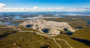
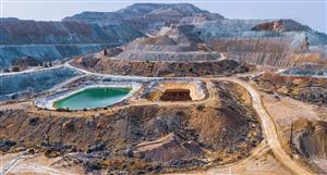
have increased surface water ponding and water table recharge. The two excavated quarries that
are approximately 4 km south of the demonstration plant site are understood to be expressions
of the water table aquifer (AECOM 2016), and support a derived groundwater dependent
ecosystem, with fauna present including fish and waterbirds.
There are no groundwater dependent ecosystems at or near the demonstration plant site and
none of the groundwater dependent ecosystems in the broader area have any hydrogeological
connection to the demonstration plant site or the strata underlying it (refer to Section 4.7.7).
4.12.2.3 Conservation
The Vulkathunha - Gammon Range National Park (50 km east of PEL 650) and Ikara-Flinders
Ranges National Park (81 km south of PEL 650) are the largest protected areas in the region. The
parks are co-managed by the Department of Environment, Water and Natural Resources and the
Adnyamathanha traditional owners. The Adnyamathanha people also manage the 58,000 ha
Nantawarrina Indigenous Protected Area, which adjoins the southern boundary of the Vulkathuna
– Gammon Ranges National Park.
Lake Torrens National Park is located 48 km west of PEL 650 and protects Lake Torrens, a large
ephemeral salt lake. Lake Torrens is listed in the Directory of Important Wetlands as ‘Inland Saline Lake’
together with Lake Frome and Lake Callabonna (DEE 2016b). This series of inland lakes
together form a complex of relatively pristine playa and ephemeral wetlands providing habitat for
large wader (bird) populations when in flood.
Ediacara Conservation Reserve is located 35 km south-west of PEL 650 and was established to
protect an internationally significant fossil assemblage and places of Aboriginal and nonAboriginal
cultural heritage.
Aroona Sanctuary, which encompasses Aroona Dam and areas around the Leigh Creek township
and was gazetted as a sanctuary under the National Parks and Wildlife Act in 1995, is
approximately 3 km south of the PEL and 10 km south of the demonstration plant location.
Warraweena, a former pastoral station which is operated as a private conservation reserve, is
located approximately 25 km south-east of PEL 650.
There are no protected areas within PEL 650.
Conservation reserves in the area are shown in Figure 4-26.


 (20min delay)