Seems a few nervous heads about...
lol...love the apparent ups and downs of minute by minute, depth induced "fundamental assessment"???
In my view, the reported increasing background gas is a significant development...especially at these depths, just into the top of the Mississippian group...and particularly in the top of Leadville.
Whilst likely not commercial, 100 units in a non-porous or tight host is a very good reading...for all we know, this may represent 100% high-pressure saturation of the available space and porosity?
Prior to both the Alkali Gulch and Pinkerton Trail highly pressured zones, which by the way are the very last two “host formations” above the current Mississipian Group location (which includes the Leadville and McCacken formations), and before we hit the Desert Creek, Barker Creek, Akah and even Upper Ismay gas zones, the company reported background gas had gradually moved from low (virtually undetectable readings), to 20, then 50, then 150 units or so prior to their respective hits, which is exactly what you would expect to see immediately above any gas horizon!
What we are seeing now is virtually a mirror image of previous drilling statistics above gas zone announcments!
For those wondering…there are examples of regional production eventuating from zones which showed as low as 250 units gas readings during drilling, but typically over wider net pay zones. Interestingly, GDN has drilled through numerous horizons with 500+ unit readings, including over 400ft or so of 400-900 unit readings AFTER intersecting the high-pressure fractured zone in the Upper Ismay. I mention this because I assume after this high-pressured intersection, they would have needed to increase mud weights significantly, which can typically hide low pressure zones further down the drill, from being detected.
I would love to see the results of an open hole flow of this entire pay zone!
Anyway, in light of the high mud weights used, the actual gas units detected through the various formations could well be significantly lower than what may actually exist...but we will not know until full behind-casing tests are complete!?
lol...once again I digress.
The fact we have any gas at all in Leadville, even the modest 100 units (and increasing) recordings to date, tells us that we increased chances of gas existing below...Leadville is clearly not barren at current depths, but possibly just not porous enough at the current bit location to be commercial. Remember...the background gas currently being recorded did not come from above, leaving only one conclusion!
Leadville is typically made up of various margins of Limestone…anything from 50-500m thick all up, so we could be drilling for some time before finally hitting a suitably porous host…in fact my own musings, based on the potential for inaccurate seismic time references due to the unexpected salt layer, put the Mississippian group, which includes Leadville and McCracken, at up to 750m deep at this location on a high side basis..
Whilst on this...I must admit I am actually a little surprised…in fact have been right along…at the apparent importance the company has placed on Leadville all this time?
Clearly it was discussed at length during pre-drill prognosis, especially in relation to the obvious geological correlations between the Golden Eagle prospect and Lisbon…but I have to say that due to the current apparent depths encountered for Leadville, I have some reservations as to it's be-all-and-end-all importance…call it a hunch as it were?
My understanding, from various regional assessment, including analysing immediately surrounding drill logs, as well as various reports on Leadville and other nearby fields, is that Leadville is not neccessarily the main target here…rather it is the “Mississippian” zone in general that is the target, which actually includes both the Leadville Limestones as well as the McCracken Sandstones…the latter of which could potentially be a much better target from my analysis?
In fact, GDN’s own pre-drill geological reports for this location did not even rate the Leadville Limestone as a “potential pay zone” in some of their notes, rather nominating McCracken as the main target zone in the Mississippian Group in preference to Leadville which was only listed as a secondary target?
Obviously the emphasis changed along the way...not sure how or why though?
This has troubled me for some time, but I figure management know more about this than me…I guess we will see?
Many might not realise this, but we actually still have at least at least five targets (including Leadville) to go and possibly up to seven as of tonight…
Mississippian Group:
Leadville Limestone (reservoir)
*McCracken Sandstone…nominated pre-drill “potential pay zone”
Devonian Group:
Ouray Limestone (reservoir)…not shown in companies pre-drill prognosis?
Elbert (producing zone at Aneth field)…not shown in companies pre-drill prognosis?
Cambrian Group:
*Lynch Dolomite…nominated pre-drill “potential pay zone”
Muav Limestone
Bright Angel Shale
The two zones not mentioned pre-drill may be a result of their non-existence at this particular location…but I have found mention of these additional formations in various geological documentation for the area. I am not a geo however, so will not pursue this other than a brief mention.
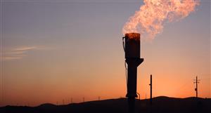
Anyway…the main thing in all of this for me is the significant gas zone in the Alkali Gulch…a somewhat unexpected result and due to it’s apparent offset to expected depth, may be a significantly bigger accumulation than many might realise.
The other significant zone of course is the Pinkerton trail highly pressured zone…in what seems like the first available host below the unexpectedly thick salt dome…and whilst clearly a Pennsylvanian formation, the fact it is structurally controlled by the same fault trap as the Mississippian group…and also forms below the unexpected salt dome...in my view, effectively renders it a Mississippian formation for the sake of this well!
In particular, its location bounded by two separate vertical fault-traps and underlying a significant salt dome, suggests it is charged by the same source as would potentially charge Leadville and McCracken, which of course most likely comes from below…and we all know what that means!
The following is the actual original image on which the GDN schematic images (the one in each announcement), has been loosely based…
I assume these images are more proportionally correct, given they are actually a product of the siesmics, as such we can make certain depth predictions as in the next image.
Now here is the above image again with my seismic adjusted references, based on reported intersection depths…
As you can see, we are barely into the Mississippian group as of today’s announcement, with significant potential depth still to go…anywhere along which we may well encounter porous host, or indeed fractured high pressure zones. We know the gas is down here from the background readings…all we need now is to find suitable host.
Whilst Leadville is obviously of interest due to the Lisbon connection, as I have mentioned previously, I think the Golden Eagle prospect will eventually be viewed for its own importance. In light of this, my interest is somewhat heightened for McCracken…a sandstone based sequence which could potentially provide wider and much more porous net pay zones.
I guess the sad truth right now however is that the market has got itself in such a lather here, it will sell-off any disappointment in Leadville, when in actual fact McCracken may be a better host…and the really REALLY sad thing is that a lack of hydrocarbons from here on will be viewed negatively regardless of how good previous results to date have been.
I reckon we already have between 200-500bcf…but this is really just a guesstimation on my part, albeit one based on some detailed methodology.
The Alkali Gulch in particular, in my view, due to it’s offset location in relation to the fault trap, potentially covers a much bigger footprint now than initial prognosis…same with the Paradox Gas/Oil intersection…all of which appear long forgotten at the particular point in time.
Lol.
Cheers!
Seems a few nervous heads about...lol...love the apparent ups...


Add to My Watchlist
What is My Watchlist?