Nearmap Expands Partnership With New Jersey To Provide Aerial Images Of Entire State, Offering Extra Resource to Government Agencies
Nearmap aerial imagery will help the state of New Jersey protect its natural lands in areas such as wetlands, transportation, and other state-run areas
October 05, 2021
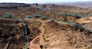
SALT LAKE CITY, Oct. 05, 2021 (GLOBE NEWSWIRE) -- Leading aerial imagery companyNearmap announced today its next steps in a growing partnership with the state of New Jersey, to help streamline decision-making in isolated areas, by taking aerial images of the entire Garden State. Until now,Nearmap only flew a part of the state, not including forests and wetlands, but now will fly those parts of the state that government agencies need to help make informed decisions regarding environmental protection and other government planning.
“Expanding this partnership with Nearmap has been a game-changer for the New Jersey Department of Environmental Protection by improving our ability to make critical decisions on environmental protection and resilience planning,” said New Jersey Department of Environmental Protection Assistant Commissioner Elizabeth Dragon. “The increased imagery of our forests and wetlands helps us determine the best course of action to protect our natural lands while being a reliable source of visual information. Up-to-date historical geospatial data is enabling us to improve planning and better protect public health, safety, and the environment across New Jersey.”
Before this increased coverage agreement, Nearmap flew roughly 70% of the state, mainly over large cities and neighborhoods, but the Department of Environment Protection (which has jurisdiction over the entire state) saw a need to fly over the natural lands they protect. As other agencies within the state government saw Nearmap aerial imagery, they began to recognize the benefit of a complete flyover of the state and saw how the imagery could also help solve other state challenges.
“We’ve enjoyed working with the state of New Jersey and their innovative team that has now provided a way for state agencies to use aerial imagery while eliminating the complicated purchasing process commonly associated with government agencies,” said Tony Agresta, General Manager of North America at Nearmap. “We are proud to be an asset to help agencies across the state of New Jersey and provide them with a source of truth to help them make decisions that will benefit the people that live, work, and play in the state.”
Nearmap is unique in its capture of aerial imagery, focusing on currency, consistency, coverage, and ease of access. Nearmap recently expanded its global mapping coverage and now covers more than 80 percent of the United States population, including 130,000 square miles of additional, unique captured footprint, double the number of urban areas covered with oblique and 3D content at a high resolution ranging from 2.2 inches to 3 inches. This increase in coverage enables agencies and organizations such as the state of New Jersey to improve decision-making capabilities.
Market Newswire


Add to My Watchlist
What is My Watchlist?