Modern eyes to uncover ancient copper paths
North of 60 Mining News - June 6, 2025
A.J. Roan, Mining News | Last updated Jun 05, 2025 2:13pm0
ShareXShare
Wikimedia Commons 1/5
A Kwakwaka'wakw man holds a tłi̓na̱s copper shield – a powerful symbol of wealth and status. From the Pacific to the Arctic, copper held enduring cultural value across Indigenous nations, despite thousands of miles of distance (Photo by Edward S. Curtis, c. 1914).
Samuel Hearne, A Journey from Prince of Wales's Fort in Hudson's Bay to the Northern Ocean (1795) 1/5
Historical map of the Coppermine River, surveyed by English explorer Samuel Hearne during his 1771 expedition to the Arctic Ocean.
1/5
Samuel Hearne
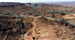
White Cliff Minerals Ltd. 1/5
Exposed copper-bearing outcrop at the Rae project, part of White Cliff Minerals' exploration in the historic Coppermine River region.
Wikimedia Commons 1/5
The Mackenzie Large Igneous Province (in purple), including the mineral-rich Coppermine River volcanics (in light blue) near the Arctic coast.
Wikimedia Commons 1/5
A Kwakwaka'wakw man holds a tłi̓na̱s copper shield – a powerful symbol of wealth and status. From the Pacific to the Arctic, copper held enduring cultural value across Indigenous nations, despite thousands of miles of distance (Photo by Edward S. Curtis, c. 1914).
Samuel Hearne, A Journey from Prince of Wales's Fort in Hudson's Bay to the Northern Ocean (1795) 1/5
Historical map of the Coppermine River, surveyed by English explorer Samuel Hearne during his 1771 expedition to the Arctic Ocean.
1/5
Samuel Hearne
White Cliff Minerals Ltd. 1/5
Exposed copper-bearing outcrop at the Rae project, part of White Cliff Minerals' exploration in the historic Coppermine River region.
Wikimedia Commons 1/5
The Mackenzie Large Igneous Province (in purple), including the mineral-rich Coppermine River volcanics (in light blue) near the Arctic coast.
Wikimedia Commons 1/5
A Kwakwaka'wakw man holds a tłi̓na̱s copper shield – a powerful symbol of wealth and status. From the Pacific to the Arctic, copper held enduring cultural value across Indigenous nations, despite thousands of miles of distance (Photo by Edward S. Curtis, c. 1914).
New copper potential emerges in historic mineral belt across Nunavut, Northwest Territories; draws fresh exploration interest.
Long before geologists mapped its contours or explorers sank their first pickaxes, there was a region of Northern Canada where copper ran through both the land and the lives it shaped. Stretching from Nunavut into the Northwest Territories, this basalt-born corridor forged tools, trade, and identity for the Inuit and Dene, who knew its value centuries before it was measured in profit – a value now resurfacing as a new chapter of discovery unfolds.
Samuel Hearne
In July 1771, guided by Yellowknives Dene across hundreds of miles of subarctic wilderness, English explorer Samuel Hearne stood along the banks of a northern river that would come to bear the name Coppermine.
There, in search of the copper rumored to lie in abundance along its course, he saw no glittering outcrops – only rock and water.
According to Hearne's own account, after reaching the Coppermine River, his Indigenous companions led him approximately 30 miles (48 kilometers) south to a known copper site.
"After a sleep of five or six hours we once more set out, and walked eighteen or nineteen miles to the South South East, when we arrived at one of the copper mines, which lies, from the river's mouth about South South East, distant about twenty-nine or thirty miles," he wrote.
What he found bore little resemblance to the stories that had spurred the expedition.
"This mine, if it deserve that appellation, is no more than an entire jumble of rocks and gravel, which has been rent many ways by an earthquake... Through these ruins there runs a small river; but no part of it, at the time I was there, was more than knee-deep."
The image of abundance – hills "entirely composed of that metal, all in handy lumps, like a heap of pebbles" – dissolved into tedium and disappointment.
"Their account differed so much from the truth, that I and almost all my companions expended near four hours in search of some of this metal, with such poor success, that among us all, only one piece of any size could be found. This, however, was remarkably good, and weighed above four pounds."
While this marked the first written record of copper in the region by a European, it was far from the beginning of its story.
Significance of copper
Wikimedia Commons
A Kwakwaka'wakw man holds a tłi̓na̱s copper shield – a powerful symbol of wealth and status. From the Pacific to the Arctic, copper held enduring cultural value across Indigenous nations, despite thousands of miles of distance (Photo by Edward S. Curtis, c. 1914).
The Dene and Inuit had long known where to look and how to use what they found – shaping tools, weapons, and trade goods from the native metal scattered along streambeds and hillsides.
Their expertise with copper was born of intimate familiarity, refined over generations and deeply integrated into the rhythms of survival and trade.
"Their hatchets are made of a thick lump of copper, about five or six inches long, and from one and a half to two inches square; they are bevelled away at one end like a mortice-chissel. This is lashed into the end of a piece of wood about twelve or fourteen inches long, in such a manner as to act like an adze: in general they are applied to the wood like a chissel, and driven in with a heavy club, instead of a mallet."
These were not rudimentary tools hastily fashioned from what was available, but purpose-built implements reflecting intentional design – practical, durable, and familiar to those who used them.
"The men's bayonets and women's knives are also made of copper; the former are in shape like the ace of spades, with the handle of deers-horn a foot long, and the latter exactly resemble those described by Crantz. Samples of both these implements I formerly sent home to James Fitzgerald, Esq., then one of the Hudson's Bay Committee."
Even with the arrival of European iron, Hearne observed, "The Copper Indians set a great value on their native metal even to this day; and prefer it to iron, for almost every use except that of a hatchet, a knife, and an awl."
Before the Hudson's Bay Company had established its post at Churchill River – and long before European standards of commerce reached the North – copper was already the basis of a seasonal economy.
"Numbers of them from all quarters used every Summer to resort to these hills in search of copper; of which they made hatchets, ice-chissels, bayonets, knives, awls, arrow-heads, &c."
That seasonal movement, repeated year after year, was as much a pilgrimage as it was a supply run – a journey sustained by toolmaking, trade, and spirit. The well-worn paths to the copper-bearing hills became arteries of a living tradition.
"Before Churchill River was settled by the Hudson's Bay Company... numbers of them from all quarters used every Summer to resort to these hills in search of copper..."
But for all its utility, the metal carried more than function – it carried meaning.
Among the stories carried forward by the Dene is one of a woman – said to be the first to reveal the copper-rich hills to her people. For years, she guided others to the site. But as the tale goes, the sole woman among the group was mistreated by the men she had led. Betrayed, she vowed to deny them the very wealth they had come to take.
"She is said to have been a great conjurer," Hearne recorded. "Accordingly, when the men had loaded themselves with copper, and were going to return, she refused to accompany them, and said she would sit on the mine till she sunk into the ground, and that the copper should sink with her."
When the men returned the following year, they found her sunken to the waist, still alive. The next year, she was gone – and with her, the greatest surface copper had vanished. Only small, scattered pieces remained.
Whether preserved as history or passed down as legend, the story endures, speaking to the significance copper held – not only in daily life, but in the deeper traditions carried forward across generations.
From tool to tale, copper was embedded in the life and legacy of the northern Indigenous peoples – a story not discovered but witnessed.
Coppermine River Group
Wikimedia Commons
The Mackenzie Large Igneous Province (in purple), including the mineral-rich Coppermine River volcanics (in light blue) near the Arctic coast.
While the Indigenous peoples of the North forged copper into tools and tradition, European arrivals saw something else – a raw material whose very existence promised commercial potential.
Word of its use filtered back through fur traders and Hudson's Bay posts, carried in the form of copper implements and embellished through retellings. It was not merely the presence of the metal that drew attention, but the fact that it was rumored as surface copper – naturally exposed and of quality and quantity sufficient to justify deeper incursions into the northern wilderness.
In the decades that followed Hearne's expedition, others set out in hopes of confirming and expanding upon the stories he returned with. By the early 20th century, federal geological surveys began to chart the region in earnest – first tracing known reports, then identifying new zones of interest.
What emerged was not a single copper showing, but a much broader corridor of mineralization stretching more than 300 kilometers (roughly 185 miles) southwest from the shores of Coronation Gulf.
These copper-bearing formations, preserved in sequences of volcanic and sedimentary rock, came to be known as the Coppermine River Group – part of the larger Mackenzie Platform. Mapping through the 1920s and 1930s revealed horizons of mineralized basalt and breccia, layered with iron-carbonate alteration and crosscut by faults and intrusions that hinted at deeper processes.
Later, this understanding evolved into the Great Bear Magmatic Zone – a vast metallogenic belt formed by ancient tectonic activity.
This system, stretching across hundreds of kilometers, encompassed both the Coppermine River region and surrounding terrain, and showed potential not only for copper, but also silver, uranium, cobalt, and other critical minerals.
These same ridgelines Hearne once dismissed as scattered fragments were now recognized as part of a vast and complex mineral province shaped by deep time, pressure, and volcanic heat, and still unfolding as modern exploration continues to reach further into its depths. As geological understanding deepened, so too did the discoveries.
Between the 1950s and 1970s, a series of exploration campaigns confirmed what early observations had only hinted at – extensive zones of stratabound copper-silver mineralization hosted within the volcanic flows and sedimentary beds of the Coppermine River Group.
One of the most notable findings came at the northwestern extent of the belt, near what is now known as the Redstone River area. Here, companies and federal geologists identified broad horizons of disseminated and vein-hosted copper, with grades that suggested both scale and continuity.
Outcrops traced mineralized trends for more than 100 kilometers (62 miles), with grab samples returning grades exceeding 3% copper in some localized zones.
Farther south, along the Kendall River and other tributaries, additional mineralized basalts and breccias were outlined – building out the picture of a copper system not limited to isolated showings but woven into the stratigraphy across the region.
These discoveries were not developed into mines – the logistical constraints of the era, coupled with low copper prices and the remoteness of the region, forestalled commercial production. However, they laid the groundwork for modern interest, anchoring future exploration in a data-rich context rather than relying on rumor or anecdote.
From that foundation, the stage was set for today's explorers to return – not to find the story of copper, but to pick up where it had paused.
Samuel Hearne, A Journey from Prince of Wales's Fort in Hudson's Bay to the Northern Ocean (1795)
Historical map of the Coppermine River, surveyed by English explorer Samuel Hearne during his 1771 expedition to the Arctic Ocean.
Modern potential revival
A convergence of global pressures has refocused attention on regions once considered too remote, too expensive, or too early to develop. The sheer volume of copper now projected to be required – not only for electrification but for the basic developmental needs of a growing global population – has made the question of where, not if, new supply must come from.
According to a recent study by researchers at the University of Queensland, Cornell, and the University of Michigan, copper demand could exceed 3 billion metric tons by 2050 under high electrification scenarios.
Even under more conservative assumptions, the world still needs to build dozens of large-scale copper mines to meet minimum baseline needs – a task made harder by declining grades and longer permitting timelines in established jurisdictions.
This shift in outlook has transformed the calculus for companies operating in frontier territories.
In the Coppermine River Group, a clearer picture has emerged from decades of piecemeal exploration. Historical programs carried out in the 1960s and 70s by Noranda and others returned surface samples grading as high as several percent copper, with associated silver. The mineralization was found along predictable horizons, often within reduced sedimentary layers or brecciated flows. Though never developed into mines, these early results form the geologic backbone that modern companies are now re-evaluating.
White Cliff Minerals, an Australia-based explorer, holds a commanding land position over more than 3,500 square kilometers (1,350 square miles) of this terrain, anchored by its Rae project.
This district-scale holding encompasses multiple structural and stratigraphic targets mapped by federal geologists as prospective for sediment-hosted copper-silver deposits.
The company has identified three high-priority corridors for follow-up, and legacy sampling has returned values up to 3.4% copper and 33 g/t silver, supporting analogies to other world-class stratiform systems.
To the north, Sitka Gold Corp., through its subsidiary Arctic Copper Corp., controls roughly 7,500 hectares (18,525 acres) in two blocks near the Coppermine River. The company has received drill permits and is preparing for further exploration within terrain historically surveyed by Cominco, with previously documented copper occurrences.
Though smaller in footprint, Sitka's project benefits from focused mineralized zones previously identified through government mapping and industry programs.
What makes this region newly viable is not just the risin
g position of copper, but the combination of historical data, airborne geophysics, and emerging infrastructure corridors in Nunavut and the Northwest Territories.
New logistics models, combined with the scale of White Cliff's Rae project and the advanced readiness of Sitka's Coppermine River asset, have shifted the threshold of what constitutes a development-ready district.
Despite these promising entries into modern mining across an ancient and storied landscape, the region remains largely untouched and geologically underexplored. The scale of its potential – suggested by historical exploration, informed by Indigenous knowledge, and supported by evolving geoscience – far exceeds what has been tested to date.
As the world's appetite for copper continues to outpace supply, this northern corridor stands not only as a frontier of opportunity, but as a proving ground for the future of responsible, discovery-driven development.
New worldclass copper potential emerges in historic mineral belt across Nunavut


Add to My Watchlist
What is My Watchlist?
