Hi All,
Good to see a lot of new posters to the NEA story; enlivening the discussion. Welcome aboard.
And Ya, what are you doing here? I haven't seen you stray from hydrocarbons for...since when? Great to have you.
Regulars will know I've been around this story for 7 years and still a top 20 holder....a very happy one. But I'm always testing for weaknesses and threats to the business model.
So first lets just clear up a bit of concern about satellites Vs aerial. Satellites are currently attaining, in ideal atmospheric conditions 20cm resolutions with 50-70cm more the norm; NEA/aerial can get 5-7cm generally. This is a huge difference for 2 basic reasons. 1) clarity of course and 2) most importantly, that pixel can be assigned much more accurately to a very specific GIS (LIDAR assisted) coordinate and not just in 2D but 3D. Satellites have several weaknesses: 1) vertical resolution is poor (ie ability to assign a pixel to the vertical is not as good as aerial which with LIDAR and vectoring from side photos can be very accurate and assign a pixel to with 5-8cm (and better) of its true altitude. 2) cost: about $20m is the cheapest GIS satellite and 3) not flexible: you can't move them so you need 16-20 to 'cover' the terrain.
But the important point here is that this is not about just good pictures. Its all about cost effective accurate pixels/data. This is why roofing/solar business, real estate, construction, insurance, mining, councils etc use aerial...because they can review, quote and plan with accuracy from NEA's data. They cant do that sufficiently from satellites.
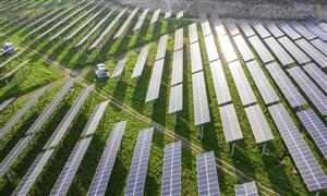
The coloured pixel you see is the very simplest piece of clay in a brick in a house. Behind each one there are many complex algorithms working to place that pixel as accurately as possible, identify it, and get it to interact with many other primary and third party data bases and all this with industry specific user-friendly platforms. For example: NEA has a huge data base on every type of solar panel available so that a contractor can very quickly quote the best price Vs energy efficiency as possible. Is not just about the picture.
OK competition; none here in Australia - from a SME viewpoint...Yet. SME/businesses aren't interested in Google because it doesn't assist or make their job easier.. (investpro69 and a few others are keen on WSR/Spookfish but refer my WSR post). In the US there are plenty. Most notably is Pictometry but NEA's main differentiation here is good ol fashioned PRICE. Pictometry offer a user a years access for us$16,650; NEA offer about A$1000/user (albeit that there maybe some data usage limitations). So all of a sudden, NEA has crashed a well stacked party and is likely to be the sexiest one on the room. I believe they could easily smash their projected 2017 revenue run-rate or US$30m.
The real reason why this biz is attractive:
Its proven,
Its costs are known,
There a good clean, healthy balance sheet,
Management are obsessed with attaining/beating goals,
and best of all...
It so easily and globally scalable.
But watch out. Because there is a real potential time-monster in this one. The data base. Who here can fathom the potential value of a highly/legally accurate, consistent pictorial data base 5-10-20 years deep?. Now that's a $B++ dream.
Cheers,

Add to My Watchlist
What is My Watchlist?