"The CITIC Group is one of China’s largest state owned companies. The off-take agreement committed CITIC to take 100% of the Molybdenum and Tungsten concentrates to be produced from the Molyhil project.
Efforts to establish a replacement agreement will be made as metal prices improve" going to something like $435 for tungsten from last dfs definantly would be appealing enough for CTIC to enter a second agreement id say - not to mention a greater resource upgrade imminent -
Thor is a mineral exploration and development company with an advanced tungsten/molybdenum project poised for development and exciting precious and base metals exploration projects. The Board seeks to increase shareholder value by systematically exploring its resource portfolio. Thor’s Directors are experienced in the mineral and finance sectors. They are practised in: evaluating mining assets; raising funds on international capital markets; evaluating acquisition and investment prospects and the day to day management of public companies. Thor has a portfolio of properties in the Northern Territory of Australia, and in Western Australia.
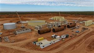
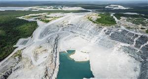
THE MOLYHIL TUNGSTEN-MOLYBDENUM PROJECT The Molyhil deposit occurs in two adjacent skarn bodies that contain outcropping molybdenite and scheelite mineralisation. Since mid 2004 it has been the subject of systematic testwork comprised of geophysical exploration, diamond and RC drilling programmes, surface and underground bulk sampling, metallurgical testwork and a geotechnical study.
BASE METAL AND URANIUM ASSETS Thor acquired a number of project areas in the Northern Territory of Australia with prosepectivity for base metal and uranium mineralisation with a history of exploration and proximity to existing discoveries. Several of the projects have had prior exploration, which was in most cases inadequate. The projects are at various stages of evaluation.
Hale River Project The Hale River project covers 160km2 of Tertiary basin sediments. These sediments are prospective for palaeochannel roll-front type uranium deposits. Previous exploration of this project area, undertaken between 1979 and 1981, delineated a redox front within sands containing anomalous uranium.
The tenement constituting this project is granted. The Company’s exploration program commenced with an airborne HoistEM survey over the interpreted redox boundaries and was followed by drilling of target zones. Previously identified lignite seam will also be drilled as these represent for high-grade uranite of coffinite where lignite has been replaced by black uranium oxides.
Harts Range Project The Harts Range project cover 362km2 of the Proteerozoic Harts Range Metamorphic Complex. The tenements were explored for uranium between 1992 and 1995 following the flying of the airborne radiometric and magnetic surveys. Numerous occurrences of uranium mineralisation were found, many of which were associated with alteration along structural breaks or contacts.
Thor’s exploration program initially focussed on structurally controlled high grade mineralisation and field mapping. An EM survey was conducted in February 2010 with results expected in March 2010.
The tenements on which this project if located are granted tenements.
Plenty Highway and Bundey River Projects Thor’s contiguous Plenty Highway and Bundey projects contain about 1,200 km2 of Tertiary sediments which cover ion internally drained area within the Proterozoic Arunta Block. The sediments have the potential to host economic palaeochannel uranium mineralisation.
Curtis Pound Prospect The Curtis Pound project is situated over Proterozoic rocks of the Tennant Inlier and contains a number of identified radiometric anomalies.
The tenements on which this project is located are granted.
Current Operations
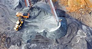
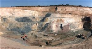
The Molyhil Tungsten - Molybdenum Project Exploration Potential There is potential within the Molyhil Project tenements to discover further mineralisation, especially within identified skarns. The ingredients of potential host rocks (carbonate sediments), sources of heat and of mineralizing fluids (granites), major structures, and conjugate minor structures are all present.
A feature of the Molyhil deposit is its high magnetite content. Similar covered deposits should possess an easily recognised magnetic signature. In addition the target rocks have relatively thin surficial cover and have not been subjected to intense weathering that could have depleted their geochemical signatures.
The Molyhil deposit is the most developed prospect within the project area. Three shafts have been sunk within the Southern Skarn and crosscuts driven from their bases across the width of the mineralised body. This process provided a clearer indication of grade than was obtained from the recent drilling programme. It also provided a large mineralised sample for future metallurgical test-work.
The Molyhil deposit remains open at depth with potential to increase resources with deeper drilling; deeper drilling was carried out successfully in October 2006, April 2007 and January 2009.
Summary of Rounded Resource Estimates – 15.25% Fe2O3 Lower Cut •Measured Resource of 540,000 tonnes at 0.33% WO3 and 0.24% MOS2 •Indicated Resource of 2.3 million tonnes at 0.38% WO3 and 0.18% MOS2 •Inferred Resource of 900,000 tonnes at 0.15% WO3 and 0.2% MOS2
Note: Totals may differ from sum of individual items due to rounding
Metallurgical As part of the Feasibility, metallurgical test work was undertaken and the resultant process flow sheet was incorporated into the economic and technical assessment. The studies indicated that a saleable concentrate could be produced.
Subsequently, additional metallurgical tests to further optimise the floatation conditions and concentrate grade and recoveries has been completed by independent consultants.
Primary Molybdenum Concentrate assayed 51.4% with a recovery of 77.8% and Primary Tungsten Concentrate assayed 72.9% WO2 with a recovery of 65.4 and they have now been established as the base to produce a saleable concentrate. Marketing and off-take Agreement Thor negotiated an off take agreement with CITIC Australia Trading Limited (”CITIC”), which has now lapsed. The CITIC Group is one of China’s largest state owned companies. The off-take agreement committed CITIC to take 100% of the Molybdenum and Tungsten concentrates to be produced from the Molyhil project.
Efforts to establish a replacement agreement will be made as metal prices improve. Environmental Approvals Thor has completed the Public Environmental Report for the Molyhil Tungsten and molybdenum Project. This report has been accepted by the Department of Regional Development, Primary Industry, Fisheries and Resources in the Northern Territory (DRDPIFR). This is a very exhaustive document that covers every aspect and possible impacts that the operations could incur at Molyhil. It is also a very stringent requirement that all aspects are indentified and a suitable management plan is put in place to ensure there is no impact on the Environment by the Operations.
Uranium Assets Thor has a number of project areas in the Northern Territory of Australia with prosepectivity for uranium mineralisation with a history of exploration and proximity to existing discoveries. Several of the projects have had prior exploration, which was in most cases inadequate. The projects are at various stages of evaluation.
Hale River Project The Hale River project covers 160km2 of Tertiary basin sediments. These sediments are prospective for palaeochannel roll-front type uranium deposits. Previous exploration of this project area, undertaken between 1979 and 1981, delineated a redox front within sands containing anomalous uranium.
The tenement constituting this project is granted. The Company’s exploration program commenced with an airborne HoistEM survey over the interpreted redox boundaries.
The first and second phases of a comprehensive uranium exploration program at Hale River have been completed.
The first phase of the program comprised a helicopter borne Hoist EM survey covering the company's Hale River and Plenty Highway tenements, which cover some 1,200 sq km of tertiary basin sediments.
The Hale River data has indicated a complex south easterly striking channel structure. Zones of conductive and resistive sediments (indicating reducing and oxidizing environments) have been interpreted within the main and subsidiary paleo-channels within the model. The revised modelling has also incorporated previous exploration drilling that has already identified anomalous areas of 'roll front style' uranium mineralisation.
Reconnaissance air core drilling at the Hale River Uranium Project has been completed with a total of 28 holes completed to date for 1,549m.
The Hoist EM survey was a technical success and identified numerous potential "trap sites" or conductive sediments within the Hale River paleo drainage system. Drilling indicated that the modelled depth to basement was essentially correct and that the conductive horizons identified in the Hoist EM survey were associated with the carbonaceous sediments, pyritic sands and lignite horizons and were not due to saline/hyper saline ground water. The drilling was difficult due to running sands and clay layers and high water flows.
Five of the six priority anomalies identified were tested with at least one hole to check the ground conditions, however the most prospective Hoist EM trap site with the coincident surface radiometric anomaly on the eastern side of the tenement could not be drilled due to access restrictions imposed by the Central Land Council.
Anomalous scintillometer readings several times background were associated with pyritic sands, carbonaceous clays and lignite. A number of samples returned assays between 20 and 100ppm U, these are considered anomalous and correlated well when compared to results from similar lignite horizons identified in the Hale River Basin by Alcoa in the 1980's.
Existing anomalies need further drill testing and work to date has confirmed the presence of suitable "trap sites" for roll front style Uranium mineralization.
Harts Range Project The Harts Range project covers 362km2 of the Proteerozoic Harts Range Metamorphic Complex. The tenements were explored for uranium between 1992 and 1995 following the flying of the airborne radiometric and magnetic surveys. Numerous occurrences of uranium mineralisation were found, many of which were associated with alteration along structural breaks or contacts.
Reconnaissance sampling of the Harts Range tenement area was completed during October and November 2006, with several areas traversed. The main objective of the sampling program was to identify known prospects and determine optimal access routes and logistics for follow-up exploration. The project includes six tenements.
In the October program, eleven rock chips were taken on two out of the six granted tenements. Analysis was completed for 39 elements.
Five samples were taken at the Ryoma and Casper prospects, with results confirming the prosepectivity of this area returning elevated uranium values ranging from 121ppm to 227ppmU. Results were also elevated in rare earth elements ("REE") such as Yttrium and Zirconium. Sample HR8 also returned up to 1.62% Pb.
The results included a single sample result of 31.6% U. This hand-picked sample contained a significant portion of visible uraninite. Significantly, a number of large pegmatite bodies are located within the Harts Range Project.
Work to date in the Harts Range Project indicates that sporadic high uranium grades occur along NW trending structural corridors, suggesting a vein-type model for mineralisation such as that at Schwartzwalder in Colorado (USA). Mineralisation here occurs in numerous lenses associated with a major shear fault network and along contacts between mica schist and gneissic rocks.
Hatches Creek Thor’s Hatches Creek Project comprises two contiguous exploration licences EL22912 and EL23463. It is located in the central portion of Australia’s Northern Territory, about 325km northeast of Alice Springs and 160km southeast of Tennant Creek. Access from Stuart Highway is via unsealed dirt roads for a approximately 165km.
The two tenements cover an area of 63.41km2 and together cover the historical Hatches Creek Wolfram Field. Numerous underground mines exploited quartz veins containing wolframite (tungsten) until the 1950’s when the mineral field closed due to falling tungsten prices.
Mining of eluvial deposits containing wolframite, gold and copper also occurred. The Hatches Creek Wolfram Field has not been systematically explored for tungsten and other commodities such as gold and copper since the field closed in the 1950’s tested for gold mineralisation. Vein and shear structures together with eluvial and alluvial sediments can now be systematically tested for tungsten, gold and copper mineralisation using modern exploration techniques.
Tungsten is used in tool steels and specialist industrial applications. For more information see the Tungsten Fact Sheet.
Initial reconnaissance mapping and sampling has been completed together with a thorough literature review of all historical data covering the area. Detailed photography and low level aeromagnetics have been compiled covering the area.
An agreement has been made with traditional owners allowing exploration activities to commence on the tenements now that both exploration licences are granted.
http://minesite.com/company/thor-mining-plc
THR Price at posting:
2.5¢ Sentiment: LT Buy Disclosure: Held
A personalised tool to help users track selected stocks. Delivering real-time notifications on price updates, announcements, and performance stats on each to help make informed investment decisions.


 (20min delay)