Happen to find some previous indications of GPR results results carried out by "Elementos" back in 2009. These deep leads extend over 15kms, of which only 5kms have historically been mined from 1856 to 1885. On average, these alluvial palaeochannels are six metres in thickness and with gold grades reported of up to 120 grams
per cubic metre (g/m3), many averaging
between 10 and 12 g/m3. If the same amount of gold can be found in the remaining 10 kms, we will be siting on some tidy profits. Should here some news in the coming months, as a decision has to be made in regards to purchasing this lease soon.
" The terms of the Option Agreement entered into are for an initial payment of $20,000 payable in Renison shares, with a further payment of $40,000 (50% cash and 50% in Renison shares) in 12 months. In the event of exploration success the terms of a Tenement Transfer Agreement have been also been agreed which would see 100% of the tenement acquired by Renison for $500,000 plus a net smelter royalty to the vendors of 1.5%. The consideration will be payable in either cash or shares at Renison’s election.
The minimum cash payable for the tenement transfer will be $100,000. The shares would be issued at a discount of 10% to the 7 day volume weighted average share price at time of issue."
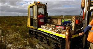
"Sydney Flat radar program
During the quarter, Elementos completed a sub-surface investigation of the deep
lead channel system using Ground Penetrating Radar (GPR) at the Houpeton
section of the Sydney Flat Exploration Lease (EL6918). Sydney Flat covers the gold
prospect areas in a broad belt surrounding Uralla. The deep lead comprises a southwest
to north-east trending belt of relict alluvial prospects (Figure 3). These are
interpreted to be residual from a braided stream environment, which brought goldbearing
sediments down from the Tenterfield area. The streams were subsequently
in-filled by lava flows during the Tertiary period, trapping the gold-rich sediments
beneath the flows.
The initial exploration strategy for Sydney Flat is to determine the most continuous
and prospective areas of the deep lead system and to use GPR to ascertain the
profiles of the individual channels (width, and depth from surface and to the bottom
of the lead system). The GPR is a non-destructive and non-invasive geophysical
technique for rapidly imaging the shallow sub-surface (typically up to 10 metres in
depth) and producing high-resolution colour sections in real time. The GPR survey
consisted of continuous consecutive traverses recorded along a dirt access road to
the property called Spring Creek, an area identified as being highly prospective by
the number of shallow historical workings.
Figure 5 outlines the radar-gram for one of the major lines. The upper dashed white
line represents the interpreted location of the top of the alluvials with the
approximate depth shown on the right hand side of the radar-gram. The solid white
line represents the interpreted location of the base of the alluvial channels. Typically
the alluvial palaeochannels are six metres in thickness.
The GPR results will be used as a guide for establishing the location of future drilling
programs to ensure that they intersect the deep lead sediments. It is planned to
continue the GPR surveys along the channel system to intersect the channels and
define a continuous body of sediments for testing."
Happen to find some previous indications of GPR results results...


Add to My Watchlist
What is My Watchlist?