G'day all,
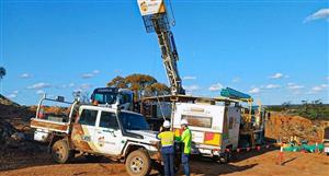
Previous geological work has shown that the Yarramba Palaeochannel flows north from Honeymoon into Curnimona's tenements. We know that CUY's initial drill program to verify the channel limits took place in their southernmost block, closest to the Honeymoon deposit.
The most recent 1/4ly report, if I am interpreting it right, seems to be inferring that this program suffered a setback in the early stages when the position of the palaoechannel as defined by the low-level EM, was not verified by first drilling ie. the channel was not where it was supposed to be.
Results from more recent drilling, which found conductive graphite in the basement rocks outside the channel, suggested that a dominant EM response from this graphite masked the signal from the less conductive saline ground waters which were to be the medium used to define the course of the palaeochannel.
What followed looks like a classic case of a drill-hole layout based on faulty base data and it was probably the operational flexibility inherent in using a Company owned drill rig that allowed planning adjustments to be implemented that got operations back on track once it became apparent that incorrect interpretation of the EM was responsible for the non-correlation with drill findings.
This early setback was probably the main reason for the apparent slow rate of progress and now that the cause seems to have been resolved we should expect an improved flow of info via progress reports.
In the event that the graphitic rocks persist throughout the full length of the palaoevalley, then all the EM collected will need to be viewed with some suspicion and alternative methods devised for defining advance drill locations.
That's my interpretation of it anyway and the latest release gives us a hint of better things.
Cheers WJ


Add to My Watchlist
What is My Watchlist?