UXA DISCOVERS 3KM ZONE OF
OUTCROPPING URANIUM MINERALISATION
PROJECT UPDATE - CRYSTAL CREEK, NT
High grade uranium - field sampling returning up to 4,120 ppm U3O8
The directors of Uranium Exploration Australia Limited (‘UXA’) are pleased to announce that the
Company has made a potentially very significant discovery at its 100% owned Crystal Creek
Project on Exploration Licence (EL) 24566, Ngalia Thrust, located approximately 320km
northwest of Alice Springs in the Northern Territory.
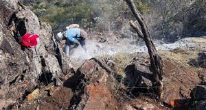
Recent field work has identified a zone of uranium mineralisation which crops out intermittently
over a strike distance in excess of 3,000m, with early field sampling indicating U3O8
concentrations of up to 4,120 ppm.
Commenting on the discovery, Managing Director Dr Russell Penney said, “We are excited by
the discovery, given the 3km length of the structure, the early indicators of high grade uranium
mineralisation and its location near to the 20.6 Mlb U3O8 Bigrlyi deposit. As such, this is
potentially the most significant discovery of mineralisation made to date by UXA”.
High uranium concentrations detected across 3km structure length
The discovery comes on the back of an airborne radiometric survey in 2007 which identified two
anomalies (Anomaly A and Anomaly B, (Figure 1), (Announcement dated 8 January 2008). In
late 2008, UXA drilled at Anomaly A which lies 3km south of Anomaly B, and discovered some
narrow zones of uranium mineralisation (best 1m @ 208 ppm U3O8).
313 Payneham Road, Royston Park SA 5070 Australia
Phone: +61 8 8363 7970 Fax: +61 8 8363 7963
Email: [email protected] Web: www.uxa.com.au
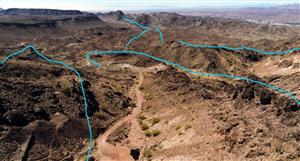
Figure 1. Niton XRF readings at Anomaly B, Crystal Creek
Table 1. Scintillometer reading & Niton XRF Uranium grade from Anomaly B uranium
bearing fault structure for values > 400 ppm U.
Easting Northing Scintillometer
Reading
Counts Per
Second
XRF
value
U ppm
XRF
value
U3O8 ppm+
741864 7541191 2,000 457+/-76 538
743558 7541753 10,000 3,500+/-209 4,123
741877 7541195 2,000 1,172+/-129 1,381
741868 7541190 1,500 1,438+/-140 1,694
741840 7541179 433+/-59 510
741831 7541169 408+/-98 481
741693 7541132 461+/-88 543
741659 7541128 900 1,221+/-164 1,438
741660 7541113 515+/-64 607
741595 7541085 1,000 450+/-102 530
742256 7541373 1,200 423+/-65 498
742408 7541436 1,300 491+/-98 578
743388 7541694 2,600 850+/-92 1,001
743557 7541750 8,000 2,835+/-177 3,340
743559 7541751 8,000 2,644+/-174 3,115
740846 7540958 1,200 414+/-66 488
740878 7540959 2,500 441+/-78 519
740891 7540959 1,500 605+/-128 713
740938 7540970 460 418+/-67 492
740963 7540972 850 795+/-109 937
740967 7540977 700 659+/-114 776
741023 7540993 500 541+/-84 637
+ Values of U are converted to U3O8 by multiplying by 1.178
Recent geological mapping has identified radiometric Anomaly B to be due to an east northeast
striking uranium bearing fault zone within granite and aplite of the Mesoproterozoic age Southwark
Granitic Suite, part of the Arunta Inlier.
313 Payneham Road, Royston Park SA 5070 Australia
Phone: +61 8 8363 7970 Fax: +61 8 8363 7963
Email: [email protected] Web: www.uxa.com.au
The structure has been traced for a distance in excess of 3km and varies in width from 30cm to
12m, averaging 3m. Uranium appears to be associated with ironstone and grades are highly
variable from trace up to 4,120 ppm U3O8. Uranium mineralisation is poddy along strike and highly
variable across strike.
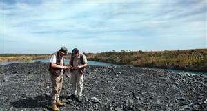
Uranium values were measured in the field using an appropriately calibrated portable Niton XL3t
XRF unit. Values in Table 1 are the maximum uranium values recorded for any single location
(point). Scintillometer and XRF readings were taken at 185 points along the structure. Of these 96
points recorded XRF uranium values of between 100 ppm U and 500 ppm U and 12 points
recorded values between 500 ppm U and 3,500 ppm U (4,120 ppm U3O8).
High uranium concentrations up to 389 ppm U3O8 have also been recorded within aplite (a type of
fine grained granite), located north east of the mapped structure and this provides a potential target
to drill a broader zone of mineralisation.
The Company will follow up this discovery and initial field work with a detailed surface radiometric,
field XRF and geochemical sampling program over the fault structure and adjacent anomalous
aplite. This work will lead to a drilling program later this year.


Add to My Watchlist
What is My Watchlist?